

South America Calling
January Forecast Favorable For South America

The weather so far in Brazil has been anything but normal in most areas. Across the central and north, it has been awfully hot and dry compared to normal. Even the wetter conditions of late have been average at best. For southern Brazil, it has been too wet, causing flooding and developmental challenges there as well. However, the second half of the first crop season is forecast to at least be fair, if not good, for reproductive and filling soybeans.
We have to get out of this week of dry weather first, however. Wet season rains shut down early this week and have become very isolated. Models have limited or no precipitation over most of Brazil's agricultural land through at least Dec. 17. That would amount to about a week of no rain and increasing temperatures. Rain is what keeps temperatures in this tropical climate from becoming extreme. When it doesn't rain, temperatures are routinely in the upper 30s to lower 40s Celsius (upper 90s to mid-100s Fahrenheit). A week of hot and dry conditions can be extremely stressful for soybeans starting to set pods at greater volume across the landscape.
P[L1] D[0x0] M[300x250] OOP[F] ADUNIT[] T[]
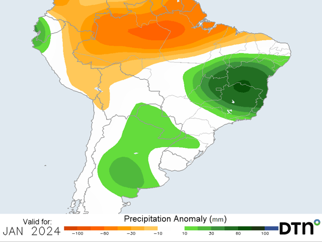
However, starting Dec. 18-19, models have precipitation moving back into central Brazil at coverage that is close to normal. Both the American GFS and European ECMWF models have decent rainfall coverage continuing through the end of their respective runs. The longer-range versions of both models are also suggestive of this sort of better rainfall through January. The European may be wetter than the American, but both models show much better coverage and amounts for central Brazil, especially in the eastern sections that include the states of Minas Gerais, Bahia, and Tocantins. Goias may be included with that better rainfall scenario as well. The state of Mato Grosso is forecast to be more up-and-down with the rainfall, but at least be close to normal. If the crop can get through the next several days of stress, it should be met by favorable weather to finish out the season.
Farther south, heavy rain and flooding dominated the early portions of the season. Developmental issues are likely as are disease problems in overly humid conditions. But this region has been somewhat drier over the last couple of weeks. Rains have come through but have not been as heavy as we have seen before. Some slow draining of soils has likely proved beneficial when combined with more sunshine for the developing corn and soybeans in these areas. Moisture is ample and in complete contrast to last season's weather. Drier conditions through the rest of this week will give way to a frontal boundary moving in Dec. 18-19. Rain showers will develop over the region, but do not look like they are of the same heavy variety as we have seen in previous months. The system will spark the beginning of some more frequent rain showers to end December. Both the European and American models have various waves of rain moving through to close out December, but nothing of the overly heavy. That continues in the extended versions of the models through January. Rain looks to be good, and overall above-normal, but not excessive. If the rain does come at a frequent pace but not extremely heavy, it should be seen as a favorable outlook for full-season corn and soybeans that continue to develop and get into their reproductive stages of growth. For the state of Parana, which follows central Brazil's schedule of a double-cropped soybean and corn crop, the outlook is also favorable, helping to fill beans and build soil moisture for the coming corn crop.
In Argentina, conditions have not been perfect, but they have been very good, and a stark contrast to last year. While November of 2022 was a good month for rain, which set up soybeans in a briefly good position, the rest of the season underperformed its rainfall. So far, only 2% of both the corn and soybean crop is rated in poor condition, according to the Buenos Aires Grain Exchange as of Dec. 7. That compares to 2% last year for soybeans and 26% for corn. Soybean planting was the slowest of the previous five years in 2022 so it was hard to judge early conditions. This year, with more than 50% of the crop planted, it is easier to accept the condition report. This week has been filled with periods of rain and that looks to continue through early next week. While a small break may occur mid- to late-next week, rain is forecast to move back into the country by the weekend.
Extended versions of the European and American models are more variable with the precipitation during January but bring in periods of heavy rainfall followed by short periods of dryness. Overall, this leads to above-normal precipitation and continued good weather for developing corn and soybeans in Argentina.
To find more international weather conditions and your local forecast from DTN, visit https://www.dtnpf.com/….
John Baranick can be reached at john.baranick@dtn.com
(c) Copyright 2023 DTN, LLC. All rights reserved.
Comments
To comment, please Log In or Join our Community .