

South America Calling
Safrinha Corn in Brazil Jumps Over First Weather Hurdle
You could argue that the wetness during the primary planting window was the first weather hurdle that the safrinha (second season) corn crop in Brazil had to jump over. Though producers were slow to get going, many areas in central Brazil made it within the primary planting window.
The south-central states of Mato Grosso do Sul and Parana had bigger delays due to wetness. But the rainfall during the wet season was the primary hurdle that needed to be eclipsed for the safrinha crop to maintain expectations of a record crop. And with just a week left to go in the wet season, it appears that the crop has successfully handled this hurdle.
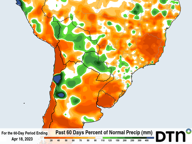
La Nina typically leads to a shortened wet season in central Brazil and though its influence was waning in February and March, there were still fears that wet season rains would end early across the country. They started to do so in late March, with more isolated showers for about two weeks, but that was short-lived as systems moving north from Argentina supplemented the lack of rainfall from wet season showers. It was not perfect, and compared to normal, the last three month's-worth of rainfall is lower than average. But rainfall was relatively consistent and heavy enough through April for most of the safrinha growing areas to limit moisture losses.
There are dry spots in the country, and some of them are large. The states of Rio Grande do Sul and Minas Gerais have issues with dryness, but those areas are minor safrinha corn growing areas. The majority of the crop is in good shape as it edges into pollination with adequate soil moisture.
P[L1] D[0x0] M[300x250] OOP[F] ADUNIT[] T[]
Due to some of those late plantings, it would be preferred to have rainfall continuing into at least early May at a regular clip to get most of the crop through pollination before shutting down the rains. There are some indications that this may be true.
After a front has gone through Brazil this week, it has become much drier behind it. But the showers are continuing in the northern growing areas going into next week, though at a much-reduced rate. Still, having some showers around will be beneficial. Across the south, there might be more concern, but a system may bring some isolated to scattered showers through April 25-26 if models are correct. Though amounts would generally be below 20 millimeters (0.8 inches), it would be enough to stave off dryness concerns for another week.
Though northern areas should dry out as the calendar turns over to May, longer-range models are suggestive of a few weaker fronts or systems moving through southern areas to continue some form of rain through most of May. With how much later southern areas were planted, the continued rainfall will be beneficial, even if it does not materialize quite as much as models suggest. It is not forecast to be much, around 25 to 50 millimeters (one to two inches) for the entire month of May, but would help to limit dryness concerns if it comes at a regular pace.
The attention then turns to the next hurdle -- temperatures. Cold shots coming with systems will be stronger and stronger with time. Going back to the 2021 season would remind us of the impact that frosts could have on corn production this year, especially given the later plantings across the south. A burst of colder temperatures moved through this week and lows on April 20 reached down into the single digits Celsius (40s Fahrenheit) in Rio Grande do Sul, but frosts were generally avoided in the main crop areas farther north.
Still, the risk of frost will only increase with time. There is some suggestion from models toward the end of May that may heighten the attention toward a risk of frosty conditions, but that is over a month away and just on the radar at this point in time. Longer-range models do not show any specific risk in June just yet, but will need to be watched as much of the crop would be in the fill stage.
To find more international weather conditions and your local forecast from DTN, visit https://www.dtnpf.com/….
John Baranick can be reached at john.baranick@dtn.com
(c) Copyright 2023 DTN, LLC. All rights reserved.

Comments
To comment, please Log In or Join our Community .