
South America Calling
Brief Boost in Rain for Central Brazil
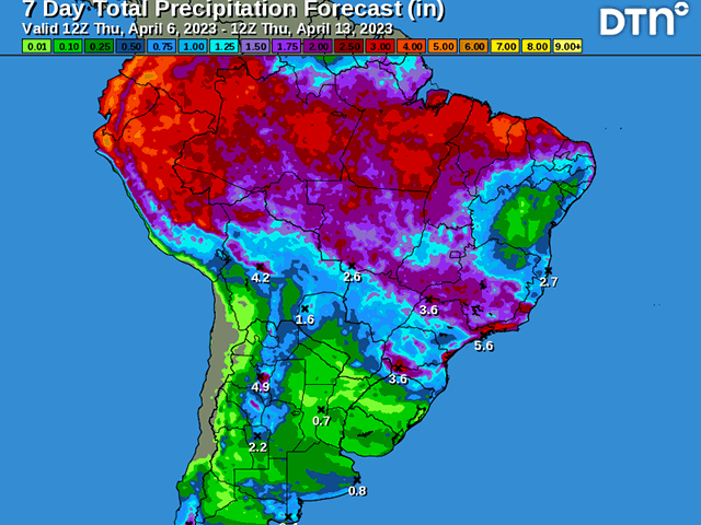
Rainfall over central Brazil has been very isolated during the last two weeks. Rainfall amounts are generally less than 30 millimeters (1.2 inches) with few exceptions. The wet season rainfall is typically in decline during April, but this year it started early, back in mid-March. Showers are still occurring but coming at much less intensity and coverage.
That changes this week as a system moving north out of Argentina will slowly move through Brazil, enhancing showers across much of the country's growing regions through the weekend. Widespread amounts of at least 25 mm (1 inch) are expected for most areas outside of Rio Grande do Sul.
In Central Brazil, those amounts may reach closer to 50 mm (2 inches) in some areas. Still, when the primary growing areas of Brazil average 90 to 125 mm (3.5 to 5 inches) for the entire month of April, without additional precipitation, the monthly totals are likely to fall below normal.
P[L1] D[0x0] M[300x250] OOP[F] ADUNIT[] T[]
Getting good rainfall is important, because some areas have seen some very late-planted second-crop (safrinha) corn. The states of Parana and Mato Grosso do Sul fell behind significantly in terms of both first-crop soybean harvest and safrinha corn planting. There have even been reports of producers foregoing corn in favor of wheat because the delays were too significant and they do not want to risk frosts during pollination or grain fill in June and July, a time that would be more likely to occur climatologically.
Central states like Mato Grosso and Minas Gerais saw a slow start to planting, but overall were able to catch up to get most of the crop planted within the preferred window. Still, there is a significant portion of that crop that was planted a week or two later than last year and more at risk of low soil moisture when the wet season rains begin to shut down.
The typical end of the wet season is in the first few days of May for central Brazil. With those wet season rains shutting down this month, Brazil will be more reliant on weather systems penetrating northward out of Argentina. But these systems are not lining up to produce many of them through the month of April.
After the one moving through this week, the next one likely won't cross the Argentine border until late next week, with showers starting up next weekend for a couple of days.
A once-per-week rate is sufficient to avoid disaster, but may leave some areas without when the scattered showers move through. Should an area miss out on one of these storms, waiting another week for a chance, when afternoon high temperatures reach up into the lower to middle 30s Celsius (middle 80s to lower 90s Fahrenheit), stress will start to increase on the developing crop.
These systems come less frequently during the dry season, the primary grain-fill period, and encroaching on the pollination period for the late-planted crop across the south. And deeper into the winter season, they come with an increased risk for frosts. Models show some hint of potential in June, but that is unsubstantiated at this time.
To find more international weather conditions and your local forecast from DTN, visit https://www.dtnpf.com/….
John Baranick can be reached at john.baranick@dtn.com
(c) Copyright 2023 DTN, LLC. All rights reserved.

Comments
To comment, please Log In or Join our Community .