

South America Calling
Heavy Rains Returning to Southern South America

It is going to be too late for some of the corn and soybean crop in Argentina and southern Brazil, but rains are finally going to come back to the region starting Jan. 15.
Heat and dryness this week have been absolutely brutal. Buenos Aires set an all-time record high temperature of 41.1 degrees Celsius (106 degrees Fahrenheit) on Jan. 12, which underscores the heat that has gripped the country during the last several days.
Since Jan. 10, temperatures have been reaching or exceeding 40 C (104 F) and are set to do it again Jan. 13-14 and possibly on Jan. 15 as well before the rains start up Saturday afternoon.
Soil moisture has been on a steady decline for weeks and crop conditions have plummeted. According to the government of Argentina on Jan. 13, only very small sections of the states of southern Cordoba and northwest Buenos Aires have adequate soil moisture. The rest have limited soil moisture or are currently in drought. Those southern areas have escaped the worst of the heat most of the summer, but not this week.
As a result of the heat and dryness, crop conditions across Argentina have been declining for weeks. Bolsa de Cereales in Argentina posted good-to-excellent crop ratings that fell from 83% to 23% in corn and 87% to 31% in soybeans between Dec. 16 and Jan. 13.
P[L1] D[0x0] M[300x250] OOP[F] ADUNIT[] T[]
The decline of conditions has led all major government and private forecasters to cut production estimates for both Argentina and Brazil. In its World Agricultural Supply and Demand Estimates (WASDE) report released on Jan. 12, the USDA cut corn production by 0.5 million metric tons (mmt) in Argentina and by 3 mmt in Brazil. But for soybeans, the USDA made larger cuts to production by 3 mmt in Argentina and 5 mmt in Brazil. Private estimates are pegged lower in most cases for both corn and soybeans. Both countries were forecast to have record production in corn and soybeans at the start of the season, but these latest estimates would put those forecasts into jeopardy.
Rains are coming but the damage has already been done to first-crop corn and soybeans in southern Brazil, which are starting harvest soon, and early planted corn and soybeans in Argentina. Argentina's farmers spread out their planting due to a long growing season as a risk management strategy to avoid having a stretch of hot and dry weather decimate their entire crop. That is crucial this year under La Nina, which typically leads to dryness in the spring and summer months and has come to fruition during the last several weeks.
The early planted crops are in reproductive and grain-fill stages of development. Rains that come will help to stabilize crop conditions and keep them from declining further, but will have limited impact on improving conditions and potential yields. The later-planted crops are still in early development stages and the drought may not have had a large impact just yet. These plants will have a better time utilizing the incoming moisture.
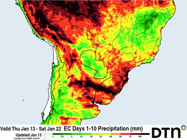
And the moisture sure seems like it will come in full force. A true break from the recent pattern, scattered showers will start to develop on Jan. 15 and continue in several clusters and waves through at least Jan. 22. The American GFS model shows another wave a couple of days later as well. All-in-all, Argentina and southern Brazil are forecast to see widespread 30-75 millimeters (about 1.2 to 3 inches) of precipitation during that timeframe and isolated areas of up to 150 mm (about 6 inches) will be possible where thunderstorms are more persistent. Both models suggest there is a higher likelihood of that to occur from northern Cordoba, Argentina through Uruguay and possibly far southern Rio Grande do Sul, Brazil, hitting a good portion of Argentina's growing regions.
As mentioned, later-planted crops in Argentina will benefit the most. But the soil moisture is needed for southern Brazil's full-season and second-crop (safrinha) corn as well. Both the European and American models are more limited in total precipitation amounts for most of Rio Grande do Sul up through Parana. Showers will be more spotty, but heavy where they occur. Still, any rain will be welcomed for the region where there were reports of some producers burying their first crop and hoping for better conditions for their safrinha crop. They would need to see some significant moisture to make that happen.
Of course, we are still dealing with La Nina conditions in the equatorial Pacific. That means that this period of wet weather will not be the norm. Long-range models are indicating that after Jan. 22 or 25, chances for showers will become more limited again through the month of February. They are not forecasting persistent dryness like we have seen during the last several weeks, but near-to-below normal rainfall amounts during a drought will not be a favorable scenario for corn and soybean production in these regions.
In contrast, the rains across the southern half of the continent will come at the expense of drier conditions across central and northern Brazil. The northern half of the continent has had well-above normal rainfall thus far this season. Almost daily moderate to heavy rains have been occurring since the middle of October. The rains were good for crop production, though there have been concerns over inadequate sunlight, but not for maturing soybeans or harvesting.
Starting Jan. 14, rains will become much more isolated in the region, allowing more producers to get out and harvest their soybeans and plant their safrinha corn. This, too, looks to be only a week-long pattern before showers fill in a bit more across this region, so the overall effect may be limited. But as I wrote last week, producers in this area of the world are used to dodging showers to get their fieldwork in. This year should be no different.
To find more international weather conditions and your local forecast from DTN, head over to https://www.dtnpf.com/….
John Baranick can be reached at john.baranick@dtn.com
(c) Copyright 2022 DTN, LLC. All rights reserved.
Comments
To comment, please Log In or Join our Community .