

South America Calling
Heavy Rains for Another Week in Argentina
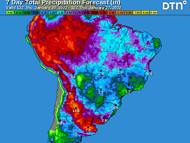
As forecast, rains started to develop over Argentina on Jan. 15. Scattered clusters, waves, and batches of moisture have been around since then. Rainfall totals thus far have been on the order of 30 to 75 millimeters (1.2 to about 3 inches) with a few areas seeing a little less and a few seeing a little more.
That precipitation has also come with lower temperatures. After breaking records with the heat last week with most days over 40 Celsius (104 Fahrenheit) across the bulk of the country, temperatures have been maxing out in the general range of 21 to 29 C (70 to 85 F) on most days, except in far northern areas which have not seen the rainfall just yet. Stress has come way down for most crops.
Early planted crops have been through irreversible damage. The heat and dryness during the reproductive and fill stages of development have taken their toll. The rains will help to stabilize conditions, but will be impossible to reverse so late in the game. Something similar happened in the northwestern U.S. Corn Belt this past season. Crops staved off disaster, but did not recover fully.
P[L1] D[0x0] M[300x250] OOP[F] ADUNIT[] T[]
The later-planted crop, which accounts for about 65-70% of the total corn and soybean crop this year, is in a much better position to take advantage of the rainfall. Most of this portion of the crop is still in the early development stages. And even 12% of the corn crop has yet to be planted based on the newest data from the Buenos Aires Exchange. While soil moisture conditions have been on the decline up until this past weekend, the downward trend has stopped for the time-being.
Crop conditions have indeed stabilized. According to the Buenos Aires Exchange, good-to-excellent ratings on soybeans fell from 31% last week to 30% this week. Corn saw a similar 1 percentage point decrease from 23% last week to 22% this week. However, the same data showed improvements in soil moisture. For soybean areas, soils with adequate moisture rose from 40% last week to 48% this week. A similar situation has developed in corn areas where improvements were by 8 percentage points from 47% last week to 56% this week. Crop conditions have stopped the downward momentum, and increased moisture during the next week should start to show up in crop conditions in next week's report as more and more of the total crop soaks up the available moisture.
The other drought area in southern Brazil has not fared as well with the moisture thus far. While Argentina was seeing clusters of showers, the states of Rio Grande do Sul and Parana have seen much more isolated showers. And even those have been focused closer to the coast in the east whereas the crops are grown in the west. Over the main growing regions in both states, rainfall amounts since this past weekend have been on the order of 5 to 30 mm (0.2 to 1.2 inches), though most areas have been on the lower end of that spectrum. Rain that falls quickly evaporates or transpires while temperatures reach up toward 40 C (104 F) most days as well. First-crop corn and soybeans, which are mostly filling kernels and pods and starting to be harvested, can only be stabilized at this point in their development. Safrinha (second-crop) corn, which is just starting to be planted in Parana, would benefit greatly from increased rainfall, as conditions cannot get much worse to start out a season.
Showers will stick around for another week at least. In Argentina, the rains could be excessive with another 30 to 75 mm (1.2 to 3 inches) forecast for a wide area of the central growing region. While amounts taper off as you work northward into southern Brazil, the showers will still be around and linger longer into the following weekend. Added up, models are suggesting amounts roughly equal to Argentina through Jan. 31, at least in Parana. Rio Grande do Sul is still forecast to receive about half of that, around 15 to 40 mm (0.6 to 1.6 inches).
Some ground will be made up. And, at least in Argentina, crop conditions should improve on-the-whole. But La Nina will not go away entirely. Drier conditions are forecast to follow heading into February. While long-range models are not suggesting complete dryness along with heat like we saw a week ago, crops that are trying to recover from drought do not need a further lack of rainfall as they head toward reproductive stages of growth. That will continue to be a concern moving forward.
To find more international weather conditions and your local forecast from DTN, head over to https://www.dtnpf.com/…
John Baranick can be reached at john.baranick@dtn.com
(c) Copyright 2022 DTN, LLC. All rights reserved.

Comments
To comment, please Log In or Join our Community .