

Market Matters Blog
How Low Can It Go? Mississippi River at Memphis Breaks Another Record
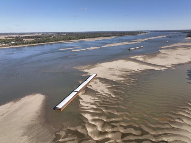
Water levels continue to fall on the Mississippi and Ohio rivers, severely affecting navigation in ways not seen since 1988, noted American Commercial Barge Lines (ACBL).
"The industry is incurring catastrophic impacts to boat capacity, which will in turn drastically decrease ton-mile productivity for the inland rivers," ACBL stated.
According to the National Weather Service observed water levels, the Mississippi River at Memphis, Tennessee, broke its recent new record low of -10.75 feet reached at 7 p.m. Oct. 17, by reaching -10.80 feet at 3 a.m. Oct. 22 and then at 5 a.m., it broke its new record, hitting -10.81 feet. The previous low record was -10.70 on July 10, 1988 (https://water.weather.gov/…).
ACBL noted the industry reduced Lower Mississippi River drafts to 9'0" on Oct. 17 both north and southbound, reflecting a 24% to 30% reduction to tons per barge versus normal conditions. "ACBL liquid drafts have been reduced to 8'6" as of Oct. 17, reflecting approximately 17% reduction to tons per barge versus normal conditions. Industry has agreed to a 25-barge max tow size SBD, reflecting a 17-38% reduction to boat capacity."
That means shippers continue to pay the same price for a barge regardless of how much is loaded in it. Hence, dead freight is incurred by the shipper. Dead freight is the amount of money paid by the shipper who is unable to load a full barge. On top of that, shippers in some spots on the river can't even load out a barge right now because the water is too low to get a barge on station.
Cash basis has reflected these issues, weakening at river terminals with conditions just mentioned. Farmers are in the midst of harvest, and many have been left looking for a new home to dump their grain at or keep it on their farm stored in grain bids or bags. The bottom line is that higher freight costs and lack of space at terminals are absorbed by farmers in the weaker spot basis bids if they need to sell.
Tom Russell, Russell Marine Group, reported the following updates as of Sunday, Oct. 23, noting that traffic is moving slowly everywhere, usually one-way traffic and operating during daylight hours only:
Upper Miss-St Louis to Cairo: Traffic is moving with intermittent dredging stoppages.
Ohio River near Cairo: Water levels were dropping low enough whereby boats could no longer operate. Water released from a reservoir helped to stabilize water and keep traffic moving. Traffic is moving slowly through Cairo. Barge fleets in Cairo are extremely congested or in some areas, inoperable due to low water.
Lower Miss-Cairo to New Orleans: New problem areas pop up on a regular basis. Memphis (M750) to Vicksburg (M437) have had the most problems. Going into the past weekend, there were five closures from M921 to M529. As of Sunday, Oct. 23, all closures have been reopened except for the latest closure at M529 that occurred Saturday, Oct. 22. Mile 529 is currently closed to all traffic while water depth surveys are being conducted.
P[L1] D[0x0] M[300x250] OOP[F] ADUNIT[] T[]
"The system needs 40-60 days of usual rainfall to replenish," said Russell. "At this point every little bit will certainly help. The ability to navigate tows is literally determined on a day-to-day basis."
LOW RIVER AFFECTING WATER SUPPLIES
Besides disruptions to barge traffic, cities along the river that rely on a strong flow for water supplies are experiencing problems as well. In New Orleans, the slow flow of the Mississippi River has caused salt water from the Gulf to move upriver. The U.S. Army Corps of Engineers, New Orleans District, began construction of an underwater sill on Oct. 11, 2022, across the bed of the Mississippi River channel to prevent further upriver progression of salt water from the Gulf of Mexico.
"Currently, the greatest risk associated with the saltwater intrusion is the appearance of unsafe salinity levels at the intakes of municipal drinking water intakes in Plaquemines Parish. Additionally, the U.S. Coast Guard has issued navigation restrictions around the sill construction site from river mile 63.5 to 64," said the USACE New Orleans District.
At Cairo, Illinois, water levels are below what is considered to be low stage. On Oct. 18, the Tennessee Valley Authority said on their Facebook page, "To help stabilize commercial navigation conditions on the lower Ohio and Mississippi rivers, we are scheduling special water releases from Kentucky Dam on the Tennessee River and Barkley Dam on the Cumberland River to help low river level impacts."
On Oct. 21, TVA said, "We continue to provide a steady flow of water from the Kentucky Dam on the Tennessee River and Barkley Dam on the Cumberland River because of low river levels on the lower Ohio River and the Mississippi River near Cairo, Illinois, and to aid commercial barge traffic.
"Kentucky and Barkley Lakes are forecast to remain in the normal operating range for this time of year between 354'-355'."
Just prior to the first announcement from the TVA, Illinois American Water said in an Oct. 15 press release, that, in order to help support continued reliable water service in the Cairo area, it was temporarily changing its source water from the Ohio River to groundwater due to historic low river levels. "Until further notice, Illinois American Water's Cairo District will be using groundwater supplied by a well which is an alternate source of water supply at the Cairo Water Treatment Plant."
Russell added, "On behalf of all concerned parties within the U.S. and the millions of people (and animals) around the world dependent on delivery of U.S. grain and other products, we must acknowledge the heroic efforts by the men and women working in the river industry. This includes personnel in the U.S. Army Corps of Engineers, the U.S. Coast Guard, water control in each river state, barge towers and operators, tow boat captains and crew, and fleet operators.
"In no way have they retreated to their safe spaces to wait it out. They have been showing up every day to fight conditions and navigation difficulties never seen. They will surely continue to show up each day and work together in an orchestrated effort to keep barges and material moving."
Mississippi River St. Louis, Missouri, hydrograph: https://water.weather.gov/…
Mississippi River at Memphis, Tennessee, hydrograph: https://water.weather.gov/…
Ohio River at Cairo, Illinois, hydrograph: https://water.weather.gov/…
Mississippi River hydrograph at Rosedale
Mississippi River hydrograph at Vicksburg, Mississippi:
Mississippi River hydrograph at New Orleans, Louisiana:
Mary Kennedy can be reached at mary.kennedy@dtn.com
Follow her on Twitter @MaryCKenn
(c) Copyright 2022 DTN, LLC. All rights reserved.

Comments
To comment, please Log In or Join our Community .