Ag Weather Forum
IRI Summer Forecast Points to Western Corn Belt Dryness Due to La Nina Influence
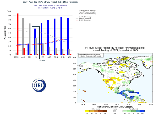
The International Research Institute for Climate and Society (IRI) published its global and regional seasonal climate forecasts this week. A primary feature of the forecast array is that a change in Pacific Ocean conditions from the (warm) El Nino to the (cool) La Nina now has a 60% chance of occurring during June-July-August -- the heart of the Northern Hemisphere row crop season. Earlier seasonal forecasts from the IRI suggested that La Nina chances would not surpass the 50% level until July-August-September.
"During March 2024, there was a further decline in the sea surface temperatures (SSTs) within the central-eastern equatorial Pacific Ocean compared to the preceding month ..." the IRI forecast commentary noted.
P[L1] D[0x0] M[300x250] OOP[F] ADUNIT[] T[]
That change in forecast ocean conditions brings with it a mixed pattern in precipitation outlook for mid to late summer. Eastern Corn Belt areas have near- to above-normal precipitation, with the highest probability in the Ohio Valley. However, the Western Corn Belt has a drier pattern suggested. The prospect for below-normal precipitation covers the southern half of Iowa, northern Missouri, northeastern Kansas, and almost all of Nebraska and South Dakota. This is a sharp contrast to the March forecast, which had climatological odds for normal, below- or above-normal precipitation in the Western Corn Belt. Meanwhile, summer temperatures have high prospects for above normal. The implication is that mid to late summer in the Western Corn Belt has a very warm, possibly hot, and dry pattern as row crops go through their pollination, flowering and filling phases.
This suggested pattern has a strong analog year in analysis by DTN long-range forecasters. That year is 2010, when the Pacific had a rapid (by ocean and atmospheric standards) change from El Nino in the spring to La Nina by July. For corn, two of the Top 5 production states -- Iowa and Nebraska -- are in the drier region. In Nebraska, the drier trend encompasses non-irrigated acreages. About one-third of Nebraska corn production historically is non-irrigated.
Forecasts for the Pacific at this point in the year have a mixed performance record; nonetheless, the forecast change to one that leans toward La Nina development by midsummer is significant in its potential impact on crop production during the filling and ripening stages. This scenario is one that we have seen before.
In the DTN lead analog year of 2010, a change from El Nino to La Nina during the growing season was described as a "rapid transition" in the USDA-NASS final crop production report. The report also noted: "The late-summer dryness, along with ... hot weather, trimmed yield prospects for some rain-fed summer crops." U.S. corn production, which had been forecast at record levels in August, had final numbers that were more than 7% below the initial estimates.
See more about analog years at https://www.dtnpf.com/….
Bryce Anderson can be reached at Bryce.Anderson@dtn.com
(c) Copyright 2024 DTN, LLC. All rights reserved.


Comments
To comment, please Log In or Join our Community .