Ag Weather Forum
Cloud Cover Forecast for Monday's Eclipse
April 8 will feature a total eclipse, when the moon travels between the sun and Earth and casts its shadow over North America. A narrow band will be lucky enough to be in the zone of totality, when the moon will be the perfect size so that only the sun's corona will be visible for a few minutes.
The path of totality will travel through portions of 13 states from Texas to Maine and garner all sorts of attention, probably more than the last eclipse in the United States on Aug. 21, 2017. But to get the full experience of the eclipse, you have to be in the path of totality under clear skies.
That can be hard to do in the springtime, when storm systems are moving through at a regular clip and some low-level clouds may hang around into the afternoon in some areas. Unfortunately for some viewers, it does appear that skies may be clouded out along portions of the path, but the forecast is not all that simple.
P[L1] D[0x0] M[300x250] OOP[F] ADUNIT[] T[]
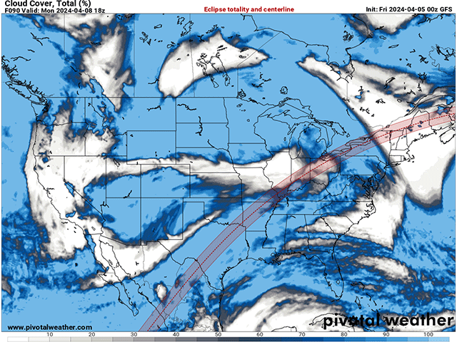
A storm system that is currently in the West will move into the Plains this weekend, with the low center spinning in the Upper Midwest on Monday. The storm will send a front south and east where it will stall from West Texas up into Lake Michigan by midday Monday. Areas south and east of the front, which will be the majority of the path of totality, will be subject to potential cloud cover. Not all areas will be experiencing thick clouds, but some probably will be.
According to most models, the path of totality from Texas into Arkansas will be clouded out, as will a stretch near Lakes Erie and Ontario. Some clouds may still be around between the two cloudier sections. Only the section from the Adirondacks in northern New York through Maine is forecast to see completely clear skies as the system's front would not be close enough to produce clouds just yet. If you are headed that way to view it, you are likely to have good luck.
But even these cloudy areas come with some caveats. Not all clouds are created equal. These model forecasts are for total cloud cover, not of clouds of a particular type, and just because cloud cover may be forecast at 100% doesn't necessarily mean that your view of the event will be completely blocked. Thick blankets of stratus clouds in the middle atmosphere would be the worst possible experience, as there would be very few holes to view the sun. That looks likely over Texas as well as spots near the Great Lakes.
But spottier low-level cumulus clouds, or high and wispy cirrus clouds could offer enough breaks or light through to witness the event decently anyway. Those higher clouds will be moving from Texas northeastward near the path of totality Monday afternoon. So, folks in northern Arkansas and southeast Missouri may be alright while those in southeast Oklahoma and southwestern Arkansas may not. Some lower, patchy cloud cover may make some folks in southern Illinois up through Ohio have a bad view, but others could luck out with completely clear skies.
I, myself, have found a spot in Hot Springs, Arkansas. When I booked this spot last summer, I was hoping for the climatologically better spots to have lower cloud cover, which is farther south and west through the path of totality. In actuality, I might not have the best viewing spot, but I'm still hoping for a good event. Who knows, I may just luck out with the higher, wispy cirrus clouds.
And even if it is cloudy, it doesn't mean you won't notice anything. With the sun being blocked out, you would still see a nighttime situation, though cloudy. You would still experience some of the indirect effects of the eclipse as well, including briefly cooler weather, a change in wind, night insects and animals emerging, day insects and animals going quiet, and flowers folding in. And even now, the forecast may change. Cloud cover can be a tricky forecast near fronts a couple of days in advance. You will want to check your local forecast often.
To find more weather conditions and your local forecast from DTN, head over to https://www.dtnpf.com/…
John Baranick can be reached at john.baranick@dtn.com
(c) Copyright 2024 DTN, LLC. All rights reserved.


Comments
To comment, please Log In or Join our Community .