

Ag Weather Forum
Drought Plagues the Canadian Prairies Prior to Spring Planting
When it comes to weather patterns across the United States this winter, El Nino has taken center stage providing above-normal temperatures to northern areas and wet conditions across the Lower Delta and Southeast. Much like the U.S., the Canadian Prairies has dealt with its share of influences from El Nino. Between the lack of consistent precipitation and above-normal temperatures, drought has anchored itself across the Canadian Prairies. More precipitation will be key heading into the late winter and early spring, but can it materialize in time for spring planting?
El Nino made its presence known in November and December across the Canadian Prairies as temperatures remained above normal across the region. El Nino typically occurs when well-above-normal sea-surface temperatures are observed across the tropical Pacific Ocean. In November, portions of southern Alberta and southern Saskatchewan observed temperatures of 2 to 4 degrees Celsius (3.5 to 7 degrees Fahrenheit) above normal. Above-normal temperatures did not let up in December either as temperatures reached 4 degrees C (7 degrees F) above normal throughout the Canadian Prairies.
A blast of Arctic air from the polar vortex in January allowed conditions to cool off for some of the area. Much of Alberta reported temperature anomalies of 2 to 3 degrees C (3.5 to 5.5 degrees F) below normal. But farther east, temperatures remained above normal across Saskatchewan and Manitoba.
Precipitation anomalies also showed signs of being influenced by El Nino. From November through January, observed precipitation anomalies approached 10 millimeters (0.4 inch) below normal across the Canadian Prairies.
P[L1] D[0x0] M[300x250] OOP[F] ADUNIT[] T[]
The above-normal temperatures and below-normal precipitation is a typical El Nino pattern for the Canadian Prairies during the winter. However, there is another climate pattern that works in conjunction with El Nino that leads to these temperature and precipitation patterns. The Pacific-North American Oscillation (PNA) also plays a role in influencing Canada's climate during El Nino. Typically, during El Nino, the PNA will allow for a ridge to develop across Western Canada and expand southeast through the course of winter. A ridge is typically associated with drier and milder conditions. Therefore, El Nino and the PNA worked together to create the climate pattern that has been observed across the Canadian Prairies thus far this winter.
Looking ahead to this spring, the impacts of El Nino may lessen, but will it be enough for improvements in soil moisture and drought? DTN's seasonal precipitation outlook for the Canadian Prairies from March through May suggests precipitation will be near normal. Temperatures are favored to be above normal across the region during this same period as well. Even though precipitation may be favored to be near normal, above-normal temperatures may not help the drought situation.
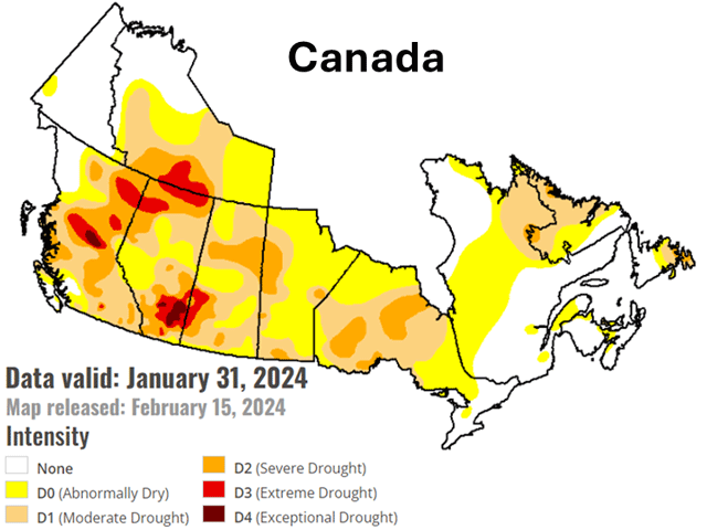
Currently, the National Drought Mitigation Center has parts of southern Alberta and southwest Saskatchewan in D3 (extreme) and D4 (exceptional) drought. Farther east, Manitoba is not experiencing nearly the drought conditions as its neighbors to the west. Most of Manitoba is covered in D0 (abnormal) to D2 (severe) drought. Much of the drought in these areas is not only a result of lower precipitation this winter, but it stems back to drought that plagued the area last summer. The plumes of smoke drifting south from Canada's wildfires last summer and fall were just one of the many signs of vegetation that had been depleted of moisture.
By May and June, producers across Canada will begin to plant their small grain, oilseed, corn, soybean and other crops. Soil across the Canadian Prairies needs more moisture late this winter into early this spring to ensure crops have sufficient moisture once they are planted.
The impacts of El Nino have a chance of dwindling this spring which could allow the persistent ridging across Western Canada to break down and allow more storm systems to move through the region. Unfortunately, most of southern Canada may not be able to shake the above-normal temperatures this spring. But moisture will be the biggest factor going forward to help improve the drought situation across the Canadian Prairies. Without more moisture, crops may get off to a poor start early in the growing season, and that could lead to yield impacts by this fall.
DTN is forecasting that El Nino will diminish this spring and La Nina will develop by this summer. La Nina typically occurs when below-normal sea-surface temperatures are observed across the tropical Pacific Ocean. Across North America, La Nina can lead to a ridge developing across the continent, which could end up forming over the Canadian Prairies. If persistent ridging does end up developing across the Canadian Prairies this summer, this would spell trouble for developing crops as heat and moisture stress could be risks throughout the growing season.
Even if the weakening El Nino can lead to near-normal precipitation this spring, this moisture may not be enough to reduce the pockets of D3 and D4 drought in Alberta and Saskatchewan. Precipitation would likely need to be above normal this spring for any drastic improvements to the drought situation for the Canadian Prairies.
You can find more information about soil moisture across Canada from Agriculture and Agri-Food Canada here: https://agriculture.canada.ca/….
To find more international weather conditions and your local forecast from DTN, head over to https://www.dtnpf.com/…
Teresa Wells can be reached at teresa.deutchman@dtn.com
(c) Copyright 2024 DTN, LLC. All rights reserved.

Comments
To comment, please Log In or Join our Community .