Ag Weather Forum
El Nino Winter Ending Like It Began -- Warm
Cold air has been hard to come by for the U.S. this winter. Thanks to a very strong El Nino that has had a persistent influence on our winter pattern, temperatures have been record breaking in many ways. El Nino in part describes anomalously high sea-surface temperatures in the tropical Pacific Ocean. When El Nino occurs, it promotes a split jet stream that keeps the northern tier of the country warm and the southern tier active and cooler. With the strength of El Nino reaching over 2 degrees Celsius above normal heading into the winter and maintaining strength throughout the season, this background feature has been more common than any other pattern this winter.
There have been some disruptions, though. When they have occurred, it generally meant near-normal temperatures across the U.S. and some periods of rain and snow. Sometimes it came with some below-normal temperatures. But those instances were very brief, lasting just a couple of days before the warmth returned.
However, there was one long-duration visit from the polar vortex in mid-January that will keep this winter from being the warmest ever in parts of the Northern Plains, and out of the top 10 in the Central Plains. Temperatures 30-40 degrees below normal flooded the central portions of the country for a time, lasting up to 10 days in the Northern Plains, but less than a week farther south and east. That brief visit was not enough to curtail the overall warm pattern.
P[L1] D[0x0] M[300x250] OOP[F] ADUNIT[] T[]
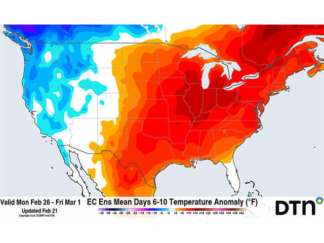
And that pattern started on day 1 of winter in early December and has been consistent throughout the three-month period. A ridge developing in the central and eastern U.S. this week continues that trend to close out the last few days. Temperatures during the period will average 5 to 15 degrees Fahrenheit above normal through Feb. 29. And even the inclusion of one more day on this leap year with some cooler air moving through will not be able to buck the trend.
That colder air is coming from a more active period to end the month as well. A system currently in the West on Feb. 21 will move through the middle of the country through Feb. 22 and produce some good rain in the Ohio Valley. But it is too warm for snow. A cold front will follow behind it with a brief burst of some cooler air for the eastern Midwest and Northeast Feb. 24-25, but that will quickly be replaced by another burst of warmth.
A larger trough in the upper levels is going to set up for next week, however, and winter is going to try to make a last stand of sorts as it generates a strong storm system. The trough will be diving south from Alaska and parts of the Arctic down into western Canada for Feb. 24-25. This stronger trough will be carrying some colder air with it, but it will largely stay there. Instead, the large trough will pick up another smaller trough over the Pacific Ocean and send it eastward next week. That should make for another round of widespread rain and snow for western states Feb. 25-27 that will move through the rest of the country Feb. 27-29. With the cooler air in Canada, that should allow for precipitation on the backside of the storm to produce some snow and bring in a brief shot of colder air in the last day or two of February. However, because the air is being mixed from the colder Canadian air and the milder Pacific air, temperatures will not turn out to be all that cold. Daytime highs are generally expected to be around normal while overnight lows could be a few degrees below normal.
But that shot of cold is brief, lasting just a day or maybe two, before the warmth returns heading into March. It has truly been a remarkable winter season due to the strong El Nino.
**
To find more weather conditions and your local forecast from DTN, head over to https://www.dtnpf.com/…
John Baranick can be reached at john.baranick@dtn.com
(c) Copyright 2024 DTN, LLC. All rights reserved.


Comments
To comment, please Log In or Join our Community .