

Ag Weather Forum
Spring-Like Weather for Midwest and Plains by Jan. 31

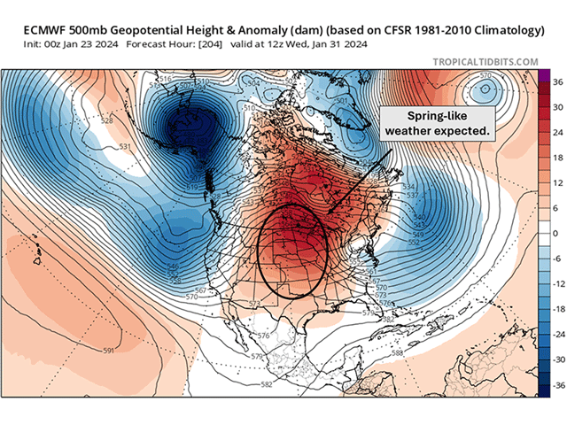
Could it feel like spring across the Central United States by Jan. 31? Forecast high temperatures across much of the Plains and Midwest on Jan. 31 currently suggest that it may feel more like April than the end of January. While above-normal temperatures are already starting to expand across much of the country this week, an even stronger warmup may take place next week thanks to an upper-level ridge that's currently developing in the Eastern Pacific Ocean.
Upper-level troughs from the Eastern Pacific Ocean continue to influence the weather across the South-Central and Southeast U.S. this week. As of Tuesday morning, parts of east-central Texas have reported up to 1.5-3.5 inches of rain in the past 24 hours and they will continue to see additional rainfall through Wednesday before receiving a bit of a break until more rain arrives on Friday.
Much like the Southern Plains, the Southern Delta will see its share of rain throughout the rest of this week. The National Weather Service issued flood watches across Louisiana, southern Arkansas, and northern Mississippi on Tuesday that called for additional rainfall amounts between 3-5 inches with locally higher amounts up to 4-7 inches by late Wednesday. These same areas across the Southern Delta are also experiencing extreme (D3) and exceptional (D4) drought according to the U.S. Drought Monitor that was released Jan. 18. This week's rainfall should help reduce pockets of D3 and D4 drought along with improving water levels along the Mississippi.
P[L1] D[0x0] M[300x250] OOP[F] ADUNIT[] T[]
After the rounds of rainfall work across the South-Central U.S. by the end of this week, the European model suggests an upper-level ridge will move into the West Coast by Friday. Throughout this weekend, this ridge will strengthen and expand across much of the West. Towards the final days in January, the strong ridge will overtake the Central U.S.
Weather conditions typically associated with a ridge include mostly dry conditions and mild conditions. Temperatures will certainly be mild across much of the country as we head through the final days of January and into the first few days of February. High temperatures on Jan. 31 could approach 40-50 degrees Fahrenheit across the Northern Plains and Upper Midwest. Farther south, portions of Kansas and Oklahoma could see their high temperatures top out near 50-60 degrees F. High temperatures of this magnitude are more reminiscent of an early spring day rather than the middle of winter.
Any snowpack that is still left by early February across the North-Central U.S. will be at risk for diminishing even more as temperatures rise to 10-20 degrees F above normal. As of Jan. 23, parts of the eastern Dakotas, eastern Nebraska, northern Kansas, and Iowa have a snow depth of at least 10 inches.
For any winter wheat in these areas, the warmer weather will eat away at the snowpack that helps insulate the crop from blasts of Arctic air. Keep in mind that we are still in the midst of winter and the risk for cold air outbreaks isn't over. While warmer temperatures may be more enjoyable, reductions in the snowpack may pose a risk for winterkill on wheat should an arm of the polar vortex dip south into the U.S again this winter.
Looking out past Feb. 1, models hint that another upper-level trough could build into the West and undercut the ridge by the end of next week.
This could lead to more precipitation for the center of the country, but precipitation chances will also be heavily dependent on where the ridge preceding the trough moves. Longer-range model guidance suggests that the ridge may remain anchored across the Hudson Bay in Canada. If this holds, the South-Central U.S. will again be the target for more precipitation while the North-Central U.S. could stay on the drier side.
Temperatures past Feb. 1 still trend to remain above- to well-above normal for the North-Central U.S. Even by Feb. 5, DTN is still forecasting temperatures to remain 8-18 degrees F above normal across the Northern Plains and Midwest.
The above-normal temperatures across the northern tier of the country have been a common theme so far this winter and this theme shows no signs of diminishing just yet as we head into the start of February.
To find more weather conditions and your local forecast from DTN, head over to https://www.dtnpf.com/…
Teresa Wells can be reached at teresa.deutchman@dtn.com
(c) Copyright 2024 DTN, LLC. All rights reserved.
Comments
To comment, please Log In or Join our Community .