

Ag Weather Forum
Christmas Storm Dumped Heavy Snow and Freezing Rain on the Plains
From temperature records being broken to heavy freezing rain and snow, the storm system that hit the center of the United States earlier this week had widespread impacts. As of Wednesday, thousands of people were still without power in North Dakota as heavy freezing rain coated trees and powerlines in the eastern half of the state. Farther south, areas of heavy snow and strong winds created blizzard conditions throughout South Dakota and Nebraska.
By late Tuesday into Wednesday, this storm system finally weakened but left lingering rain and snow showers across the center of the country.
This storm system packed a punch due to multiple pieces of energy in the East Pacific interacting with one another as they moved into the western U.S. DTN Ag Meteorologist John Baranick explained the setup and interaction of these systems last week. You can read more about that here: https://www.dtnpf.com/…. On Dec. 23, a low-pressure system exited the Eastern Rockies and provided a mix of rain and snow across the Western Plains with rain showers and thunderstorms farther south and east. By Christmas Eve, this same low-pressure system pushed east and provided areas of showers and thunderstorms to the Southern Plains and Southern Delta. From Dec. 23-24, parts of eastern Oklahoma, western Arkansas and northeast Texas reported up to 1-2 inches of rain with isolated higher amounts up to 2.5-3 inches. Meanwhile, snow, freezing rain and rain were falling across the north-central U.S.
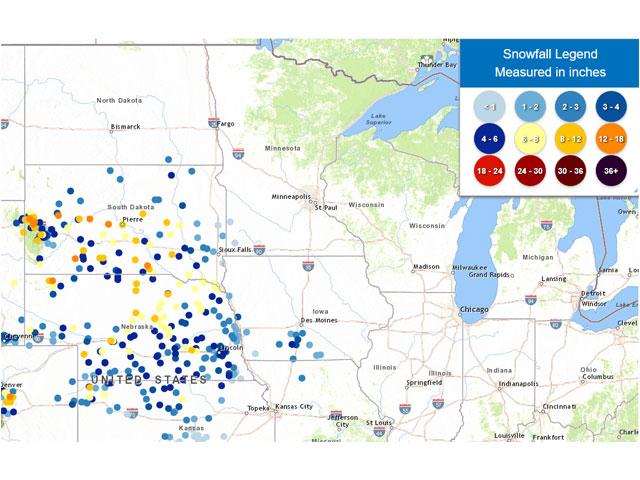
Cool and moist air on the back side of this low-pressure system led to areas of heavy snow and freezing rain continuing across the Northern and Central Plains by Christmas Day. Winds across South Dakota and Nebraska also increased throughout the day and by Christmas night, wind gusts up to 40-55 miles per hour were reported across these areas.
P[L1] D[0x0] M[300x250] OOP[F] ADUNIT[] T[]
These strong winds and areas of heavy snowfall led to blizzard conditions across the two states. Farther east, along and ahead of the system's cold front, scattered rain showers blanketed the Southeast and even areas of heavy rain fell across northern Alabama and northern Georgia. Rainfall reports approached 1-2 inches around Birmingham, Alabama, and in far northeast Georgia, up to 2.5-3.5 inches of rain were recorded on Christmas Day.
In addition to the widespread precipitation, very mild conditions accompanied the system across northern areas. Temperatures approached 20-30 degrees Fahrenheit above normal in the Upper Midwest on Christmas and some places even broke temperature records. For example, the National Weather Service office in La Crosse, Wisconsin, reported a record-warm low temperature of 50 degrees Fahrenheit. This beat the previous record of 46 degrees set in 1936.
Precipitation with this system started to diminish in intensity by Dec. 26, but lingering snow showers and gusty winds continued across the Central Plains while freezing rain fell across parts of northern Minnesota and North Dakota.
Pockets of heavy freezing rain hit southeast North Dakota. Locations along Interstate 94 between Bismark and Fargo, North Dakota, reported 0.5-1 inch of ice accumulation between Monday and Tuesday. Farther south, snowfall reports approached 6-12 inches from northern Nebraska into southern South Dakota.
The widespread precipitation with this system provided some relief to the dry conditions along the Mississippi, but more moisture is needed. In the latest U.S. Drought Monitor released Thursday morning, pockets of extreme drought (D3) and exceptional drought (D4) still exist across the Southern Delta. In the Southeast, D3 drought that was across northern Georgia in the Dec. 19 U.S. Drought Monitor vanished with the new updates on Thursday. The 2.5-3.5 inches of rain earlier this week certainly helped diminish the drought severity there.
But for areas along the Mississippi, the recent rainfall only helped raise river levels slightly. The river and its tributaries still need more consistent and heavier rainfall which could come to fruition next week.
Looking ahead into the new year, the southern Delta will have multiple opportunities for more widespread precipitation during the first week of January as disturbances from the East Pacific drift east along the southern U.S. This leads to better odds of improving water levels along the southern Mississippi.
Farther north, where the heavy snow and ice fell earlier this week, drier conditions should return through the first half of next week and temperatures will continue to be above normal.
To find more weather conditions and your local forecast from DTN, head over to https://www.dtnpf.com/….
Teresa Wells can be reached at teresa.deutchman@dtn.com
(c) Copyright 2023 DTN, LLC. All rights reserved.

Comments
To comment, please Log In or Join our Community .