
Ag Weather Forum
December a Record-Warm Month for Northern US

It was mentioned in this blog space before it began, but December turned out to be a really warm month for most of the United States and Canada. (See https://www.dtnpf.com/…)
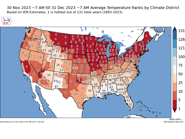
In fact, based on data gathered by the Iowa Environmental Mesonet, it was the warmest December on record across all climate districts in Minnesota and a few others in the Upper Midwest. Most of the climate districts across the northern tier of the U.S. that are east of the Rockies were in the Top 5 warmest. And even much of the Central and Southern Plains and portions of the West were in the Top 10. Only one climate district in the contiguous U.S. had a below-normal month, the one that includes Mobile, Alabama. The data record goes back 132 years to 1893. Southern Canada also had a very warm December, though data is not available to rank.
The cause of the record warmth has been an upper-level ridge of high pressure that persisted almost the entire month across most of the U.S. and Canada. Occasionally, there were some breakdowns in the ridge, one of which brought a big winter storm system for Christmas to the Plains, but the breakdowns were short-lived.
P[L1] D[0x0] M[300x250] OOP[F] ADUNIT[] T[]
In fact, the temperatures leading up to the Christmas storm were record-setting in the Upper Midwest. Minneapolis set a high of 55 degrees Fahrenheit on Christmas Eve, smashing the previous record by 9 degrees F. But it was the overnight temperatures that were even more extreme, in some cases in the 40s F across northern areas, which were 10-20 degrees F above the normal highs. You can read more about the Christmas storm's impact here: https://www.dtnpf.com/….
So, if the ridge was so dominant, why did the southern tier of the U.S. not join the north in the record-setting warmth? The answer was an active southern jet stream that brought several storm systems through the region but also brought down a bit more of that Canadian air into the Southeast. While any cool-down was brief in the north or the Plains, the southern jet stream kept the lower temperatures around longer in the Southeast. Cloud cover and precipitation also worked to keep temperatures down in the region. But outside of the Mobile area, most areas in the Southeast were near or even above normal for the month.
And typically, if the eastern half of the country is warm, the western half is pretty cool. That was not the case this year as several climate districts in the West saw a Top 10 warm December.
The very warm northern U.S. and somewhat cooler southern U.S. is a typical feature during El Nino. Almost all El Ninos, regardless of strength, produce a very warm December. It just so happens that very strong El Ninos, which we are currently experiencing, are even more likely to produce warmer readings, sometimes to the extreme. December 2015 was one of those strong El Nino years where temperatures were extremely warm for a vast area of the country. In that year, it was mostly in the Eastern U.S.
January has continued to show that warm ridge across the U.S. and Canada, but that is about to change for mid-month. I will have more to mention about that in a blog post Jan. 5.
To find more weather conditions and your local forecast from DTN, head over to https://www.dtnpf.com/…
John Baranick can be reached at john.baranick@dtn.com.
(c) Copyright 2024 DTN, LLC. All rights reserved.
Comments
To comment, please Log In or Join our Community .