
Ag Weather Forum
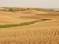
Drought Still a Problem for Canadian Prairies
Fall is a time of year the Canadian Prairies hopes for precipitation to build soil moisture before the ground freezes for winter. While there were some improvements in the total precipitation in October, including a snowstorm across the south, and at times in November, much of the region is in drought.
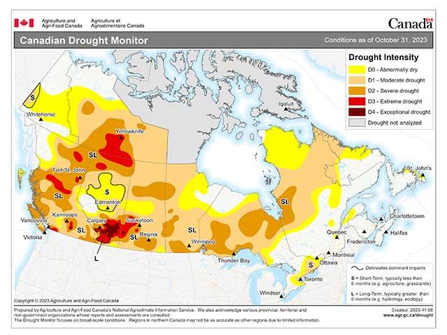
Southern Alberta and southwest Saskatchewan have had the poorest conditions over the year, leading to widespread D3-D4 (extreme to exceptional drought) classifications according to the Canadian Drought Monitor. Much of the rest of Saskatchewan and Manitoba's primary crop areas have less of a deficit, but are still in D1-D2 (moderate to severe) drought. Far northern Saskatchewan and much of central and northern Alberta have been more fortunate, with more limited drought in these areas.
There is still some time before the freeze to get some moisture into the soils, though that is becoming less and less likely as time wears on. Hard freezes and up-and-down temperatures have limited movement into the soils, which will only get worse heading into December. Highs sometimes do not break the freezing mark, though those areas nearest the Rockies are more likely to see larger temperature swings.
P[L1] D[0x0] M[300x250] OOP[F] ADUNIT[] T[]
But the prospect for additional precipitation the next couple of weeks is very low. There may be a couple of storm systems that track across northern sections of the provinces, but the downsloping winds off of the Rockies will tend to keep these systems dry. Very little precipitation is forecast through the end of the month, with most areas seeing little or no precipitation and others that do seeing less than 10 millimeters (about 0.40 inches). That does not bode well for increasing soil moisture.
In addition, a system that passes by on Nov. 20-21 will bring in a burst of arctic air, sending temperatures plummeting up to 5 degrees Celsius (about 10 degrees Fahrenheit) below normal in Alberta, and roughly 5-12 degrees C (about 10-20 degrees F) below normal in Saskatchewan and Manitoba for a few days. That could mean overnight low temperatures down to or below -12 C (10 F) for a couple of days. It's not as severe as the cold burst in late October, but still very cold for this time of year. Hard freezes will result and the edging toward a frozen soil profile will continue.
El Nino is having an impact here. The primary storm tracks shift well to the south in the States or through northwest Canada into Hudson Bay during the event. This is not a constant feature, but a more typical one during El Nino. Through the winter months, this usually leads to lower precipitation and snowfall in the Canadian Prairies, though some clippers could produce some good streaks at times.
Therefore, with drought already widely in place and a likelihood for reduced precipitation over the next several months, we could have some issues with dry soils to start out the 2024 growing season.
To find more international weather conditions and your local forecast from DTN, head over to https://www.dtnpf.com/…
John Baranick can be reached at john.baranick@dtn.com
(c) Copyright 2023 DTN, LLC. All rights reserved.

Comments
To comment, please Log In or Join our Community .