Ag Weather Forum
Heavy Rain Forecast for Central Brazil
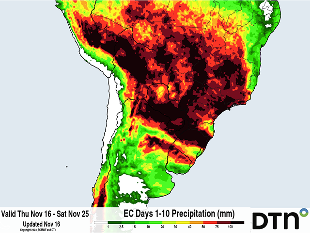
As mentioned in this blog last week, https://www.dtnpf.com/…, a change to the rainfall pattern is coming for central Brazil. Heavier rain more typical of the wet season is forecast by models starting Nov. 19.
But that is coming very late. During the past week, only spotty showers have been observed over the vast expanse of central Brazil states of Mato Grosso, Mato Grosso do Sul, Goias, Sao Paulo and Minas Gerais. These areas account for about 60% of corn and 50% of soybean production in the country. Some areas have seen very little rainfall (less than 50 millimeters, or about 2 inches) since the start of the wet season officially began in late September. Others have not been as dire, but reports from social media out of the state of Mato Grosso, the largest production state for both corn and soybeans, are a concern. Withered soybeans and replanting have become a regular feature on X, formerly known as Twitter.
With little or no rain and cloud cover to keep them down, temperatures have soared up to or over 40 Celsius (104 Fahrenheit) on a regular basis. Significant heat and drought stress increased, especially this week where there has been very little precipitation over the entire region. The wet season rainfall has gotten off to an awful start, but there is rain on the way.
P[L1] D[0x0] M[300x250] OOP[F] ADUNIT[] T[]
A front over southern Brazil will push northward into the central states Nov. 18-19 and starting on the 19th, widespread showers and thunderstorms are forecast by all available weather models for about a week. That week between Nov. 19-25 should be a good one for producers in the region. Average rainfall amounts of 50-100 millimeters (mm) are forecast regionwide. There will be winners and losers out of this as there always are with thunderstorms. But this week of rain marks a real change to the wet season. It is coming very late, but looks like it should be for this time of year.
However, after Nov. 25, models trail off this rainfall. The European ECMWF does so before the American GFS, which lingers at least decent coverage and intensity into early December. But the ECMWF is more scant with the precipitation. Looking at the extended versions of both, and their ensemble forecasts, below-normal rainfall is expected for the month of December, and could be drastically low. The GEFS, the long-range ensemble version of the American GFS, paints all of these central states except for parts of Mato Grosso do Sul and Sao Paulo with below-normal precipitation for the month, with anomalies of 100 mm or greater (about 4 inches or more) below normal in parts of Mato Grosso and Goias.
Could dry stretches like we have seen in October and November continue in December after the coming wet week? They sure could. Will they? I suppose that is too hard to say at this time. Even 100 mm below-normal rainfall is still 100-150 mm (about 4-6 inches) of rain for the month. But the crop in the ground will be stressed if it is not regular.
Much like November, a dry stretch will induce significant heat in the region. Without any significant subsoil moisture, the coming rainfall could be quickly used and dry conditions could start up the stress again.
Producers will also have to make decisions. There have been rumors of producers abandoning soybeans and planting their safrinha (second-season) crop early when the rains come back in. There have been those that have already started to replant soybeans, which could increase if the rain disappoints. Replanting of soybeans now would mean pushing a safrinha crop deeper into the coming dry season next year. Producers may not choose that risk and instead abandon a safrinha crop. Choices will be hard to make for producers there that consistently plant a strong soybean crop followed by a risky safrinha corn or cotton crop.
All this stokes fears that crop production in Brazil will be lower this marketing year. The rain coming will quell those fears at least temporarily. But what comes after will be important and shape the rest of the season's outlook. We will need to wait until after Thanksgiving to make any real assessments.
To find more international weather conditions and your local forecast from DTN, visit https://www.dtnpf.com/….
John Baranick can be reached at john.baranick@dtn.com
(c) Copyright 2023 DTN, LLC. All rights reserved.


Comments
To comment, please Log In or Join our Community .