Ag Weather Forum
Rainfall Forecast Increasing for Central Brazil
Last week, I talked about the drier conditions and forecast across central Brazil. You can read more about that here: https://www.dtnpf.com/….
I remarked about the slow start to the wet season rainfall in the middle of the country, the most productive corn and soybean growing area in all South America, and the potential concerns for the soybean crop. That crop is planted first, followed by the second-season(safrinha), corn crop, which may have some concerns as well.
At the time, the forecast was for the following two weeks to produce well-below-normal rainfall for the middle of the country. The first week of that forecast has passed and, certainly, the rainfall has been scant. Some isolated showers have developed but not nearly the coverage or amounts producers there would like to see. Estimates from DTN point to very little of the acreage eclipsing 30 millimeters (1.2 inches), or near-normal rainfall, over the last seven days. Some areas have been completely dry.
The forecast for the week through Oct. 25 is also very dry there. Most areas are forecast to see less than 10 millimeters (about 0.40 inches) over the next seven days, well below the 30 to 50 millimeters (about 1.2 to 2 inches) that are more typical as we enter the heart of the wet season rainfall patterns.
P[L1] D[0x0] M[300x250] OOP[F] ADUNIT[] T[]
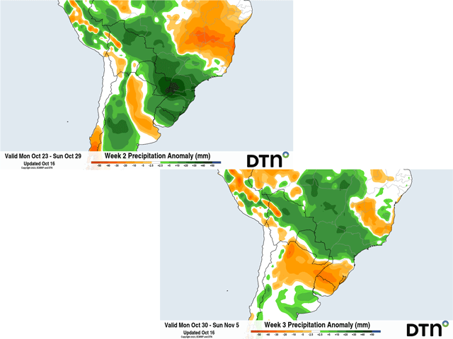
After that, models are coming around to a more typical or even excessive rainfall pattern for the middle of Brazil. Starting right around Oct. 25-26, rain is forecast to increase on both the European ECMWF and American GFS models. This comes from a front moving through and it is likely to be more active than previous fronts. Another front is forecast for early November on the GFS that sweeps up all the way north into the Amazon, another area that has been very dry and has had issues with shipping.
That week's rainfall could be more than the previous four combined. Adding it all up, it appears possible for widespread amounts of 50 to 100 millimeters (about 2 to 4 inches) across central Brazil between Oct. 25 and Nov. 3. It is not a guarantee, and a mid- to long-range forecast tends to be wrong to some degree, but the potential is certainly there. Models are in relatively good agreement now for that heavy rain to occur.
Such heavy rainfall would certainly ease concerns about how dry it has been so far. And producers have yet to care about the lack of normal rainfall anyway. Showers have still been around, enough for producers to plant their first-crop soybeans.
In the state of Mato Grosso, the largest production state for both first-crop soybeans and safrinha corn, planting progress is ahead of the usual pace. According to the Mato Grosso Institute of Agricultural Economy (IMEA), as of Oct. 13, planting progress for soybeans sits at 35%, ahead of the five-year average pace of 28%, but slower than the 41% posted last year. There has been no slowdown to the planting pace thus far. And if producers agree with the forecast, they are likely to try to get their crops in the ground before the round of heavy rains to take advantage of them.
The question will be if the active pattern will continue for the wet season. After Nov. 3, both long-range versions of the ECMWF and GFS show below-normal rainfall again impacting central Brazil through about Nov. 20, the end of the GFS run. However, the ECMWF is more forgiving about rainfall to end the month of November. And by the time we reach the end of November, below-normal rainfall won't really matter unless the rain stops altogether. When an area averages 200 to 250 millimeters (about 8 to 10 inches) of rainfall each month during the wet season, receiving even half would be enough to produce a good soybean crop.
To find more international weather conditions and your local forecast from DTN, visit https://www.dtnpf.com/….
John Baranick can be reached at john.baranick@dtn.com
(c) Copyright 2023 DTN, LLC. All rights reserved.


Comments
To comment, please Log In or Join our Community .