

Ag Weather Forum
Weather Pattern Setup Favors Heavy Rain for Central US Next Week

We have seen during the last couple of weeks, and this week as well, an upper-level pattern that has meant a general ridge in the West and trough in the East. That has generally meant warmer weather out west and cooler conditions out east, producing many areas' first frost of the season.
It hasn't been a strong ridge in the West though, which allowed a couple storm systems to move through. One last week was a heavy rain producer for a wide area of the country from Wyoming to Pennsylvania, but areas across the South and Southeast have generally been drier to go along with the milder weather. That pattern is going to flip next week. And though it may or may not be temporary, it certainly will bring risks of heavy rain to the middle of the country.
The classic setup for big storm systems feature a digging trough in the West and a building ridge in the East. The trough provides the cool air and upper-level dynamic energy, while the eastern ridge provides the heat and moisture, bringing it up from the Gulf of Mexico. When we look at the upper-level forecasts from all the models for next week, we get this classic setup. But there are some differences from that as well.
P[L1] D[0x0] M[300x250] OOP[F] ADUNIT[] T[]
For one, the western trough isn't one single entity, and the eastern ridge doesn't look like it wants to move very much. The stubborn ridge will force storm systems that leave the West and enter the Plains to travel northeast toward Hudson Bay. Being that the trough is multiple rounds of energy, we can probably expect more than one storm system or burst of rainfall to move through the middle of the country next week.
Another factor to consider is the tropics. Currently, there are a couple of low-pressure centers off the coast of Mexico in the Pacific Ocean. Both of them are forecast by the National Hurricane Center (and most models) to become tropical during the next several days. With the trough building in the West, it may guide those tropical features northward into the middle of the country next week as well. Any tropical energy combined with the moisture from the Gulf of Mexico could enhance the heavy rainfall threat.
The cold air in the West may also be enough to turn rain over to snow in some areas. With several pieces of energy, we could see multiple events as well. Models do not have a good grasp on this at all, and will need some time to sort out, but those in the Northern Plains should not be surprised to see their extended forecast to mention snow after Oct. 24.
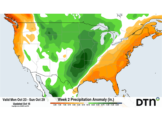
In fact, models do not have a consistent progression of these pieces of energy either between themselves, or run-to-run. Therefore, any specifics are yet to be determined including the snow potential, but also rainfall amounts, severe potential, wind speeds, and temperatures. Ahead of this zone, it should be quite warm when not being influenced by rainfall or cloud cover. The Mississippi Valley and Great Lakes may see temperatures exceeding 15 degrees Fahrenheit above normal for a couple of days, making it feel like late summer.
Rainfall amounts do look rather impressive on the models, but only generally speaking. We need some time to work out those specifics on when, where and exactly how much. But heavy rain in the middle of the country would mean reduction of drought, potential help for water levels in the local rivers, maybe even in the Lower Mississippi River that has reached several records during the past couple of weeks, and delays to the remaining harvest.
But this pattern won't last forever. Both the European ECMWF and American GFS suggest that the last few days of October will see this pattern breaking down and reverting to our western ridge and eastern trough look going into early November. We'll see if they can stay consistent on at least that fact.
To find more weather conditions and your local forecast from DTN, head over to https://www.dtnpf.com/….
John Baranick can be reached at john.baranick@dtn.com
(c) Copyright 2023 DTN, LLC. All rights reserved.
Comments
To comment, please Log In or Join our Community .