

Ag Weather Forum
Strong Fall Storm This Week With Heavy Rain, Strong Winds
Those that live in the Plains or Midwest saw a dose of fall during the last several days with frosty morning conditions that stretched from Canada to Kansas to the Ohio Valley. It is certainly that time of year, which begs the question, when will the first fall storm come through? We won't have to wait long.
If you live in Ontario or Quebec, you've already seen it. An upper-level low pressure center developed there during the weekend and has been lingering early this week. Cool weather brought areas of rain and some snow at times as well as some breezy winds.
Those in the northern Great Lakes have seen the breezes and showers as well. But another upper-level trough moving into the Pacific Northwest on Oct. 10 will cause a compact, but potent system after moving into the Plains Oct. 11. The storm center will build along the Kansas-Nebraska border Wednesday and Thursday, then move east through the southern Great Lakes for Friday and Saturday, exiting off the East Coast early on Sunday.
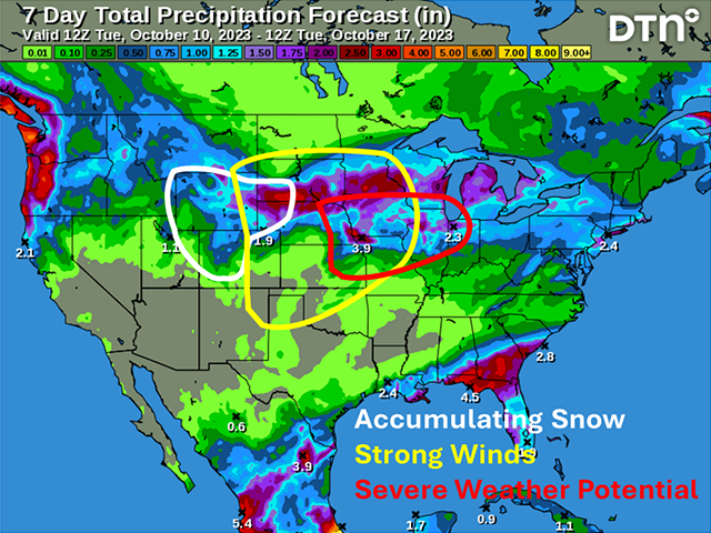
The storm system will deepen quickly midweek, which will cause a shield of rain to develop that is forecast to be quite heavy. A band and zone of heavy rain is forecast from Wyoming eastward through the Great Lakes.
P[L1] D[0x0] M[300x250] OOP[F] ADUNIT[] T[]
Rainfall amounts over an inch are forecast in the zone, with some areas forecast to see up to 3 inches where significant thunderstorms may occur.
Cold air wrapping into the system may turn some of the rain over to snow Thursday night into Friday morning. The most likely areas to see snow would be the higher elevations in Wyoming, Colorado, and the Black Hills in South Dakota, but snow may mix in or even accumulate in eastern Wyoming, southwestern South Dakota, and western Nebraska. It may be a touch too warm in northeastern Colorado.
As of 9 a.m. CDT Oct. 10, the National Weather Service only has winter storm watches out for the higher elevations. But the offices in the area are talking about potential snow at lower elevations as well, so we will see. Due to the uncertainty, it is difficult to talk about amounts.
With the system deepening rapidly, that will also mean strong winds around the low-pressure center, especially on its backside as it pulls away Thursday and Friday across the Plains.
Preliminary wind gusts of up to 60 miles per hour are expected at current, and there is potential there for some areas to peak out higher than that. The storm will actually weaken slightly as it moves through the Midwest, making the winds there breezy, but not nearly as hazardous, more likely in the 35-45 mph range for Friday and Saturday.
In addition to the rain, snow and wind, severe thunderstorms will be a possibility as well. While not overly widespread, the deep storm system will cause a significant cold front to move eastward. The Mid-Missouri Valley stands the best chance at any severe storms on Oct. 12, with lower potential farther eastward in the Midwest for Oct. 13.
Colder air filtering in behind the system will bring more fall-like temperatures to more areas next week with frosts and freezes being possible farther south than this week. Areas from the Texas Panhandle to south of the Ohio River could see some frosty conditions once high pressure settles in, winds calm down and skies clear.
The fall storm may cause some wind damage to crops still out in the fields and equipment that is left unsheltered, bring flooding where heavy rain develops, and cause some early frosts and freezes for southern folks.
To find more weather conditions and your local forecast from DTN, head over to https://www.dtnpf.com/…
John Baranick can be reached at john.baranick@dtn.com
(c) Copyright 2023 DTN, LLC. All rights reserved.

Comments
To comment, please Log In or Join our Community .