
Ag Weather Forum
Roller Coaster Temperatures, Frosts Likely During the Next Week
As relayed last week, the country will see a shift in the weather pattern and a sizeable cooldown in temperatures during the next several days. Summer-like warmth will turn to seasonably low temperatures for fall.
In doing so, there is a risk of frost across the northern half of the country, which could be damaging to any crops or garden plants that are not yet mature. The cold won't last long though, as temperatures rise back above normal again next week as we ride the fall rollercoaster.
Big upper-level troughs and ridges are scattered across North America. There is a large ridge in the East and that has built up summer-like heat across areas east of the Rockies this past weekend and into this week. Temperatures well into the 80s and 90s Fahrenheit spread through most of these areas. Ninety-degree temperatures even made it up to the Canadian border in the Red River Valley, quite a feat for Oct. 1. But a large trough is in the West, which has been bringing scattered showers since the weekend and has now started to drift into the Plains as of Oct. 3. The trough will push a strong cold front eastward for the rest of the week. Scattered showers and thunderstorms, and some severe weather, will move eastward with the front.
Behind the front, temperatures will take a quick dip downward, about 10-15 degrees from the prior day. But the true cold comes in behind that as another trough in Western Canada pushes into the middle of the U.S. a day or so afterward, helping to pull down relatively cold, near-arctic air from Canada.
P[L1] D[0x0] M[300x250] OOP[F] ADUNIT[] T[]
This time of year, that usually means frosts, but it may be harder to do.
The perfect conditions for creating frost are first to get a cold air mass to settle into the region. We will definitely see that. But we would also like to see clear skies and calm winds. Clouds can act sort of like a blanket and keep temperatures from falling too much. Strong winds tend to mix up the atmosphere a bit and can keep any cold air from settling. The upper-level low may bring some cloud cover and winds will not exactly be calm when the coldest air is moving through.
With all the recent rainfall and warmer weather, soil temperatures are well-above normal for this time of year and soil moisture is much improved as well. When soils are dry, they radiate more heat into the atmosphere, and recent rains may help keep temperatures up a bit, too.
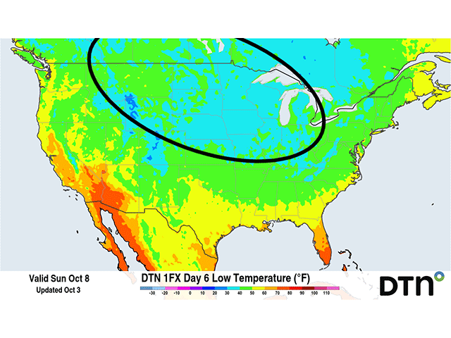
The colder air that moves in will moderate as it pushes eastward this weekend. The greatest risks for frost are currently in the Northern Plains for Friday and Saturday mornings and in the northern Midwest Saturday, Sunday, and perhaps Monday morning as well. However, if conditions change, we could see some of that frost risk as far south as southeastern Colorado and Kansas and even the Ohio Valley.
So, conditions do not look like they will be perfect. The forecast can still change, and if you are looking at non-threatening temperatures in your forecast right now, that doesn't mean that they won't become that way if we see less cloud cover or winds during the coming days.
But that's not the end of the rollercoaster. Another upper-level ridge will move eastward next week and settle over Canada. That should bring in above-normal temperatures again. As of the current forecast, that heat is much more subdued than the summer-like temperatures currently east of the Rockies. It will be more seasonably warm as the fall season really starts to kick off. Riding the rollercoaster will probably be a common occurrence for the next couple of months.
To find more weather conditions and your local forecast from DTN, head over to https://www.dtnpf.com/…
John Baranick can be reached at john.baranick@dtn.com
(c) Copyright 2023 DTN, LLC. All rights reserved.

Comments
To comment, please Log In or Join our Community .