
Ag Weather Forum
What is Behind the Big Change to the Forecast?

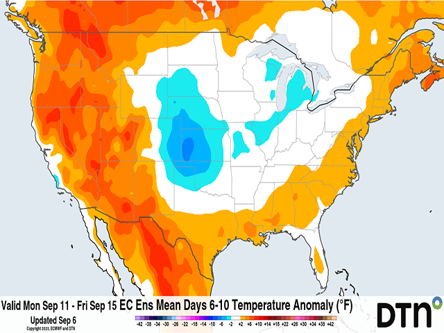
The forecast took a nearly 180-degree turn from last week and instead of extremely hot weather this week, we're getting a good push of mild air through much of the country east of the Rockies. That looks to continue for next week as well.
We still saw some significant heat during the Labor Day weekend, with many areas in the Central United States nearing or eclipsing the 100-degree Fahrenheit mark. But it did not last long as a system that moved through the Northern Plains brought a strong cold front through the western two-thirds of the Corn Belt Monday and Tuesday, and now looks to complete the sweep Wednesday into Thursday.
Models had some hint of this system producing a good cold front, as I pointed out in last week's blog here: https://www.dtnpf.com/….
But those models did not suggest anything like a drop in temperatures of 20-25 degrees F that we see now. They also suggested that any drop would be temporary and above-normal temperatures would be favored through at least mid-September, if not through the entire month.
Another front moving through the Plains this weekend, and areas to the east early next week, will bring in another round of mild air to most areas of the country east of the Rockies, and push the heat out of Texas.
P[L1] D[0x0] M[300x250] OOP[F] ADUNIT[] T[]
The strong upper-level ridge responsible for the heat was supposed to stick around all month long. Instead, it appears that it will retreat down to Mexico and occasionally bump up into Texas and the Southwest. That is what will continue the heat through early next week in the Southern Plains.
Meanwhile, another ridge will develop over Canada this weekend and next week and there will be a channel of weakness that will allow disturbances to move through the West and collect in the East. The overall trough in the East will keep temperatures mild for the most part.
It will also have the tendency to steer away any threats from the tropics, which includes fast-developing Tropical Storm Lee in the middle of the Atlantic. That storm is forecast to become a hurricane later on Wednesday and a major hurricane by Friday as it moves northwest toward the U.S. but should be pushed away by this protective trough. It may come close, however. So instead of a ridge over the Central U.S., we will more-or-less see a trough through mid-September.
What is the cause of this major shift in the models? We could blame some of it on their inability to accurately forecast the impact of the Madden-Julian Oscillation (MJO), a band of thunderstorms that circumnavigates the tropics. This feature has been studied as a link between how the tropics can affect weather patterns across the globe and especially here in the U.S. The MJO traces its beginnings in the Indian Ocean or western Pacific Ocean and travels eastward, sometimes all the way around the globe through the Americas, Atlantic, and Africa before reaching the Indian Ocean again. This happens on a time-scale of about 30 to 60 days, but can be somewhat stationary as well.
Earlier forecasts had this MJO wave moving through the Pacific Ocean throughout the month of September. History suggests that during August and September, a ridge is favored in the Central U.S. when the MJO is in the Pacific Ocean west of the Dateline, then through the Eastern U.S. as it crosses the Dateline. Hence, the hotter and drier forecast.
However, the MJO has been weaker and stalled out more into the Indian Ocean and what is called the Maritime Continent region that encompasses the island grouping of Indonesia and the Philippines. Currently, the MJO is not having nearly the effect that models thought it would have at this point last week.
The other influence would be due to El Nino, which has really taken a firm grasp on the eastern Pacific Ocean during the last few weeks and may be a partial cause in the delay of the MJO. The latest weekly sea-surface temperature departure in the Nino 3.4 region -- the region that forecasters use to describe the state of the El Nino Southern Oscillation (ENSO) -- has risen to a positive 1.6 degrees Celsius above normal. A reading of positive 0.5 degrees C is required to be in El Nino status. The current reading indicates a very strong El Nino in the eastern Pacific Ocean, and a main driver of the atmospheric circulation.
As the MJO and El Nino battle it out, temperature variability has been a regular for the U.S. It was a week of extreme heat in mid-late August, followed by another of mild temperatures in late August, then another heat burst in early September, followed by another mild period now for early-mid September. A return of the ridge and heat is being forecast by most models for late September going into early October. It is the rollercoaster of conditions that we would normally associate with periods of good rainfall, but that has not come to fruition for more than a few lucky areas so far. Drought has been increasing in recent weeks and should grow on the latest U.S. Drought Monitor update which will be issued tomorrow, Sept. 7.
There is hope for those in the Central and Southern Plains to see good rainfall Sept. 9-13, but that is not guaranteed. Otherwise, look for light rainfall amounts for most of the country outside of Michigan and the Northeast which will occur during the next couple of days.
To find more weather conditions and your local forecast from DTN, head over to https://www.dtnpf.com/…
John Baranick can be reached at john.baranick@dtn.com
(c) Copyright 2023 DTN, LLC. All rights reserved.
Comments
To comment, please Log In or Join our Community .