

Ag Weather Forum
Small Caveat to the Coming Heat: Not All US Affected
The recent change to the weather pattern has allowed an upper-level heat ridge to extend farther north since mid-August. During the period of Aug. 18-26, temperatures soared well-above normal east of the Rockies and especially in the southwestern Corn Belt where readings were 10 to 15 degrees Fahrenheit above normal for this time of year. DTN Ag Meteorologist Emeritus Bryce Anderson talked about the impact that may have on the final crop yields here: https://www.dtnpf.com/….
We are getting a break in that heat ridge this week, with readings more in line with normal across the Corn Belt, sometimes even a degree or two lower than normal for the eastern side of the region. But the break is going to be short-lived as the ridge that has since moved off into the western states, pushes back to the central and eastern U.S. during the next few days.
It does not come with a quick burst of heat, but rather a growing simmer: 90 F high temperatures are occurring in the High Plains early this week, but will shift to the eastern Plains by Sept. 1 and across the Mississippi River during the Labor Day weekend. From there, the heat will really crank up next week.
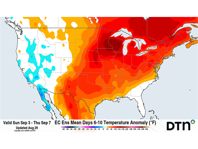
Forecasts of the heat from major weather models indicate readings that could push across the century mark as far north as Minneapolis yet again, and perhaps as far east as the Appalachians. The heat has been over-forecast by the American GFS model, which has some ridiculous ideas about how hot it will get next week, but the European model believes the heat to be extreme as well.
P[L1] D[0x0] M[300x250] OOP[F] ADUNIT[] T[]
This sort of heat is a killer for the end of the growing season and puts into doubt some lofty yield predictions from earlier in August. We have only seen small sections of the southern and eastern Corn Belt get any appreciable rainfall during the last 10 days and the forecast is not favorable for much more. However, there are some caveats to the coming heat and dryness that need to be considered.
The ridge will not cover the entire United States, nor will it be a stagnant feature. A trough is going to be situated in the western states. That trough will bring some of its energy into the ridge next week. We should see a system move through the Northern Plains on or around Labor Day. That system will leave behind a front across portions of the Northern Plains and Upper Midwest. North of that front, it will be notably cooler. For example, temperatures in Aberdeen, South Dakota are forecast to drop from the mid-90s F this weekend, into the low-to-mid-80s F next week and stay there, reducing impact from extreme heat. That front will be the key to some areas finding relief from the heat, and also potential for rainfall.
A sharp gradient in temperatures is a great way to get precipitation to form, especially one that is near a source of energy like the western trough. It would be hard to go through the entire week without showers also dotting their way across portions of the Central Plains and Midwest, dancing on the edge of the extreme heat.
However, model forecasts for precipitation are hard to describe, as they seem to be haphazardly thrown around into the general area without much in the way of a triggering mechanism. To overcome the effects of an extremely hot ridge, the atmosphere needs some sort of support. Moving fronts, upper-level disturbances, or brief wobbles in the ridge can do that, but those are not able to be forecast too well in advance.
Areas to the extreme south may also see some tropical disturbances. Extremely high sea-surface temperatures in the Gulf of Mexico, approaching 90 F, fueled Hurricane Idalia from a weak Tropical Storm into a Category 2 hurricane in less than 24 hours, then quickly into a Category 4 hurricane. The hurricane then made landfall as a Category 3 on Wednesday morning at Keaton Beach, Florida.
Small disturbances that make their way into the Gulf of Mexico underneath that ridge could do the same. It is no guarantee that anything will occur beyond Idalia's destructive forces set to go through northern Florida and portions of the Southeast on Wednesday.
But something can always pop up in there to produce more rainfall and briefly lower temperatures. There are even some forecasts that bring Idalia back across Florida and into the Gulf again, where re-intensification would be possible.
Heat and dryness are major concerns for the end of the corn and soybean fill periods and will limit the weight that the crop can put on under significant stress. Livestock will also need more considerations to keep them alive. Only some lucky areas across the north, and maybe the south, will be able to escape from the weight of the coming heat.
To find more weather conditions and your local forecast from DTN, head over to https://www.dtnpf.com/…
John Baranick can be reached at john.baranick@dtn.com
(c) Copyright 2023 DTN, LLC. All rights reserved.

Comments
To comment, please Log In or Join our Community .