

Ag Weather Forum
Hurricane Hilary Takes Aim at California, Southwest
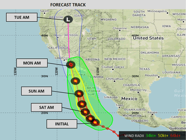
Hurricane Hilary was situated well off the coast of Mexico on Friday morning. As of 8 a.m. PDT, the storm was an intense Category 4 hurricane with maximum sustained winds of 145 mph, just 11 mph less than Category 5 strength.
The National Hurricane Center and DTN believe that additional strengthening may be possible on Friday before a weakening trend ensues.
The forecast track for the storm is north-northwest between an upper-level trough off the coast of California and an upper-level ridge in the central United States. There is a strong likelihood that the storm will make landfall in the far northern Baja Peninsula or far southern California Sunday night or early Monday morning, Aug. 20-21, but likely as a tropical storm. Colder waters (around 17-20 degrees Celsius, about 63-68 degrees Fahrenheit) off the coast of Baja California will be largely unsustainable for a tropical system. Sea surface temperatures of 26 degrees Celsius (79F) are generally recognized as being supportive for tropical systems. The cold water should result in rapid weakening of the winds.
Regardless of the actual classification, the storm has a very large footprint and will bring a shield of heavy rain into the Desert Southwest. Forecasts of widespread 2-to-5 inches of rain are common across southern California, western Arizona, southwest Utah, and much of Nevada due to the storm. This part of the country, and deserts in general, typically do not fare well with heavy rainfall and flooding is a major concern for the region.
P[L1] D[0x0] M[300x250] OOP[F] ADUNIT[] T[]
Hard-pan desert soils are a barrier for rapid penetration of precipitation, and the lack of vegetation allows for dry riverbeds to quickly flood. The rainfall at elevation is likely to be a bit higher than on the valley floors, which may lead to mudslides and debris-flows. The storm will track over highly urban areas as well, which should also lead to flooding. Agricultural lands may be better equipped to deal with the rain that falls in their own area, but the surrounding areas that are not could lead to flooding and damage there, too.
Hurricanes and tropical systems are not common to the southwestern U.S. The eastern Pacific, off the Mexican and Central American coasts, is a hotbed of tropical storm and hurricane activity. However, due to upper-level winds, storms either are sent westward through the open Pacific, or are pushed across northwest Mexico before getting into the Desert Southwest, and usually the Four Corners area.
If storms make it farther up the Mexican coast toward California, they are confronted by very cold sea-surface temperatures that quickly diminish the storms. Since 1900, only three tropical cyclones have moved through California -- the 1939 Long Beach Tropical Storm, Hurricane Kathleen in 1976, and Hurricane Nora in 1997. The first made landfall in California, the only storm to do so since 1900, and the latter two moved through the Baja Peninsula first before moving into California.
However, rain from tropical systems is more frequent. Remnants of tropical systems still produce widespread rainfall and can cause flooding. Hurricane Kay's remnants did so just last year in southern California.
The storm's remnants will track north through the western states early next week with more areas of heavy rain up through Idaho and western Montana. The Canadian Prairies may also see enhanced rain from the storm.
To find more weather conditions and your local forecast from DTN, head over to https://www.dtnpf.com/…
John Baranick can be reached at john.baranick@dtn.com
(c) Copyright 2023 DTN, LLC. All rights reserved.

Comments
To comment, please Log In or Join our Community .