
Ag Weather Forum
Late-Summer Heat Wave Building

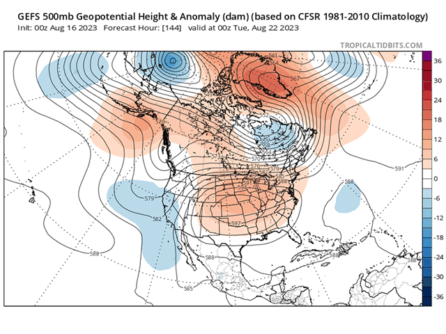
Temperatures have already been eclipsing the 100-degree-Fahrenheit mark this week in the Pacific Northwest, Montana and even parts of western Nebraska, but it is about to get much hotter farther east. An upper-level ridge, the culprit behind the heat wave, will be spreading through the middle of the U.S. for the rest of the week and weekend. Highs well into the 90s and sometimes over the century mark will be a stark change from the conditions that much of the Corn Belt has been under the last six weeks or so.
There was another heat wave of similar magnitude in late July, and this one will likely feel like that previous one. But will this heat wave last longer?
The Central U.S. heat ridge is favored on models through the end of August and likely into September as well, but there is some nuance to it. In the short term, pieces of energy will go over the top of the ridge, near the U.S.-Canada border. These should set up a cold front in the general area with milder temperatures to the north of it, as well as periods of precipitation. One piece of energy later next week should push the cold front through the Great Lakes and Northeast U.S., which will only allow for a brief hot period before near-normal temperatures slide in.
P[L1] D[0x0] M[300x250] OOP[F] ADUNIT[] T[]
The ridge will also go through some normal pulsing that will make it less intense from late next week to the end of August. But above-normal temperatures are likely to stick around through the Central and Southern Plains and adjacent areas throughout the next couple of weeks.
Here is a list of selected cities and their high temperature forecast for the rest of August from DTN as of Aug. 16. Most days are above normal high temperature throughout the forecast, except in Chicago and Cincinnati, which may see a cooldown later next week and temperatures near average if the front can make it there. If it does not, expect these parts of the Eastern Corn Belt to be a few degrees warmer than the current forecast. The peak of the heat will be this weekend into the middle of next week.
| 8/17 | 8/18 | 8/19 | 8/20 | 8/21 | 8/22 | 8/23 | 8/24 | 8/25 | 8/26 | 8/27 | 8/28 | 8/29 | 8/30 | |
| Denver, CO | 94 | 94 | 93 | 93 | 94 | 93 | 92 | 92 | 89 | 89 | 88 | 87 | 87 | 87 |
| Rapid City, SD | 84 | 102 | 93 | 89 | 92 | 93 | 88 | 90 | 87 | 82 | 85 | 84 | 85 | 87 |
| Omaha, NE | 80 | 86 | 98 | 97 | 97 | 97 | 94 | 89 | 88 | 87 | 87 | 86 | 86 | 86 |
| Kansas City, MO | 82 | 84 | 96 | 97 | 96 | 96 | 96 | 90 | 90 | 88 | 89 | 88 | 88 | 90 |
| Oklahoma City, OK | 99 | 101 | 104 | 102 | 100 | 99 | 99 | 97 | 96 | 95 | 96 | 95 | 95 | 96 |
| Dallas, TX | 108 | 109 | 107 | 108 | 105 | 103 | 100 | 103 | 102 | 101 | 101 | 99 | 99 | 99 |
| Amarillo, TX | 102 | 102 | 100 | 100 | 99 | 97 | 96 | 95 | 95 | 94 | 93 | 93 | 92 | 92 |
| Sioux Falls, SD | 80 | 92 | 100 | 98 | 98 | 100 | 92 | 90 | 87 | 86 | 84 | 85 | 85 | 82 |
| Minneapolis, MN | 77 | 84 | 93 | 92 | 94 | 92 | 85 | 84 | 83 | 82 | 81 | 82 | 81 | 83 |
| Des Moines, IA | 80 | 84 | 94 | 97 | 97 | 98 | 94 | 89 | 89 | 87 | 86 | 86 | 85 | 86 |
| Chicago, IL | 80 | 80 | 86 | 91 | 89 | 92 | 86 | 82 | 82 | 81 | 81 | 82 | 83 | 82 |
| St. Louis, MO | 88 | 83 | 88 | 94 | 96 | 96 | 96 | 90 | 90 | 89 | 89 | 89 | 88 | 89 |
| Memphis, TN | 87 | 89 | 92 | 95 | 96 | 96 | 97 | 96 | 95 | 94 | 93 | 93 | 93 | 93 |
| Cincinnati, OH | 83 | 79 | 83 | 89 | 92 | 91 | 93 | 85 | 84 | 84 | 84 | 85 | 85 | 85 |
| Nashville, TN | 85 | 85 | 89 | 93 | 93 | 94 | 95 | 95 | 92 | 91 | 91 | 90 | 90 | 90 |
Outside of those northern and eastern areas of the Corn Belt, precipitation will likely be nonexistent for most of the middle of the country, which will be very stressful for filling crops and forages. Some of these areas have seen very good and above-normal rainfall over the last several weeks, but the limited soil moisture will quickly be used up by plants over the next couple of weeks, making it an unfortunate end to the campaign. Corn is more advanced in these areas and will likely see less of an impact than soybeans or some later-planted crops, which may be further behind developmentally.
To find more weather conditions and your local forecast from DTN, head over to https://www.dtnpf.com/…
John Baranick can be reached at john.baranick@dtn.com
(c) Copyright 2023 DTN, LLC. All rights reserved.
Comments
To comment, please Log In or Join our Community .