Ag Weather Forum
Crop Indexes Show Wide Areas of Stress
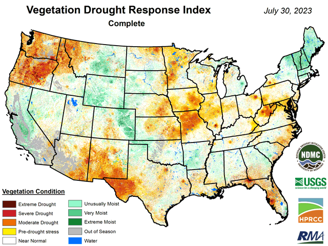
One of the more recent analysis products for clarifying how drought is affecting vegetation in the contiguous U.S. is the Vegetation Drought Response Index, or VegDRI. This index was developed with sponsorship from the U.S. Geological Survey (USGS), USDA's Risk Management Agency (RMA), and NASA. The index is produced by the National Drought Mitigation Center (NDMC) in collaboration with the USGS and the High Plains Regional Climate Center (HPRCC). Production of the VegDRI maps began in 2006 with coverage of seven states in the northern Great Plains and has since expanded to include all the lower 48 states.
It may be tempting to describe the VegDRI map as just one more rendering of the weekly Drought Monitor, but that would be short-changing the detail of the VegDRI map. The VegDRI description notes that it brings together both satellite-based observations and on-ground descriptions of land cover, land use, soil characteristics, and the ecological setting. Also, according to the VegDRI description, "The VegDRI maps that are produced deliver continuous geographic coverage over large areas and have inherently finer spatial detail (1-km2 resolution) than other commonly available drought indicators such as the U.S. Drought Monitor."
P[L1] D[0x0] M[300x250] OOP[F] ADUNIT[] T[]
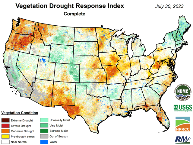
That fine spatial detail, to likely no one's surprise, reveals that crops in most of the central U.S. are under some level of stress as late summer approaches. In terms of primary crop growing areas, the VegDRI map produced July 30 showed either drought-approaching stress or definite drought stress from the eastern sector of the Great Plains east all the way to the Allegheny Plateau except for portions of northern Iowa, southern Minnesota, southern Michigan, and the immediate lower Ohio Valley. Within this large coverage of stress, vegetation from central Missouri into eastern Iowa along with western Minnesota and much of eastern Nebraska and eastern Kansas was classified as having severe drought stress. Similar conditions are also prevalent in the Pacific Northwest.
Precipitation forecasts for the next seven days do feature some heavy amounts in the northern and western Plains and the southern Midwest, with suggestions of 2- to 3-inch totals. Some of the driest and most-stressed crop areas are included in the coverage of heavier rainfall. Two questions arise regarding this prospect. First, will the suggested heavier rainfall actually occur? Second, will crops be able to make full use of the precipitation if it happens, following a period of intense heat and dryness?
Early-week grain market trends appear to offer the assessment that, despite the stress of the 2023 midseason, the adage "rain makes grain" is still in play -- if the moisture predictions come true. There are about two months yet to go before the answer to this assessment starts showing up in combine yield monitors.
Bryce Anderson can be reached at Bryce.Anderson@dtn.com
(c) Copyright 2023 DTN, LLC. All rights reserved.


Comments
To comment, please Log In or Join our Community .