
Ag Weather Forum
Lack of El Nino Jet Stream Looks Stressful for Corn and Soybeans
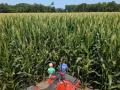
During the past several months, there has been much publicity about a "super" El Nino building in the Pacific Ocean -- an event that could be on par with 1997, 1982 and 1972 El Nino events. But so far that extraordinary event has not come together, with stressful implications for U.S. row crop weather right at the prime time for corn pollination and kernel fill, and for soybean blooming, pod setting and pod filling.
The term "El Nino" is, of course, just part of the full term "El Nino-Southern Oscillation", which Wikipedia describes as "an irregular periodic variation in winds and sea surface temperatures over the tropical eastern Pacific Ocean ... The warming phase of the sea temperature is known as El Nino and the cooling phase as La Nina. The Southern Oscillation is the accompanying atmospheric component, coupled with the sea temperature change ..." The abbreviation for the full name of the Pacific El Nino-Southern Oscillation is "ENSO".
P[L1] D[0x0] M[300x250] OOP[F] ADUNIT[] T[]
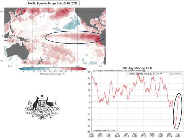
The atmospheric component of ENSO -- the Southern Oscillation -- has been tracked since 1876 by the Australia Bureau of Meteorology, using an index based on comparing the daily barometric values on the island of Tahiti and at Darwin, Australia. The index, known as the Southern Oscillation Index (SOI), helps determine whether the atmosphere is responding to the sea surface temperature changes.
Here's where the Pacific Ocean sea surface temperatures and the SOI atmospheric measurements do not show a full El Nino to be in effect. The Pacific equator region temperatures are certainly at El Nino levels, with values of 0.8 degrees Celsius to almost 3.0 degrees Celsius above average. (The El Nino temperature threshold is 0.5 degrees Celsius above average.) However, the SOI readings indicate a neutral atmosphere response as of mid-July. (SOI values of -7 or below indicate El Nino.) The SOI value for May was -15.26. However, the June value was only -3.19. And the 30-day SOI value on Thursday July 20 was at +3.16. A look at the super El Nino of 1997 shows that the June 1997 SOI value was -24.3; in 1982, the June SOI was -17.2; and in 1972, the June SOI value was -10.9.
This SOI move from a solid El Nino value in May to neutral in June and July is somewhat of a surprise to climate scientists. "I must admit that I found it to be a bit of a surprise to see the SOI return to positive values in June given that the SOI was -18.5 in May and then rose to +0.2 in June,", noted Dr. Howard Diamond, climate program manager at the NOAA Air Resources Laboratory. "I suppose that the reality is that the El Nino is yet to establish itself in the central Pacific ... My experience with past fluctuations in the seesaw between ENSO phases, is that it has a mind of its own."
But there's another aspect to this start-and-stop El Nino atmosphere pattern as well; the lingering stamp of a three-year La Nina on the entire Pacific Ocean, according to DTN weather risk communicator Nathan Hamblin. "(Three) straight years of moderate to strong La Nina conditions set up an environment that this young El Nino hasn't had enough time to change yet," Hamblin said in an email. "I think the typical El Nino circulation failed to develop in June and July because of how much warm water built up during the three straight years of La Nina in the western Pacific ... I think the sudden onset of El Nino is playing a role. It (the atmosphere) simply hasn't had enough time to unwind that western Pacific warmth."
Hamblin and other climate scientists look to mid-August as the time frame for the Pacific atmosphere to show a consistent El Nino trend. But a forecast for widespread heat and only variable rainfall until then suggests stressful conditions for corn and soybeans during their prime reproductive phases. The Pacific Ocean trend may be toward El Nino, but the fingerprint of La Nina is affecting yet one more crop season before leaving the scene.
Bryce Anderson can be reached at Bryce.Anderson@dtn.com
(c) Copyright 2023 DTN, LLC. All rights reserved.

Comments
To comment, please Log In or Join our Community .