

Ag Weather Forum
Heat Coming at Wrong Time for Corn Belt
It has been a relatively active and calm period in the Corn Belt during the last several weeks. Bouts of milder air temperatures and semi-frequent rainfall have led to overall decent rainfall during the last 30 days. There have been some winners and losers in the precipitation department, but overall it has been a nice turnaround from the dry conditions from late spring into early summer.
This pattern is about to change again, toward one of more heat and less-frequent precipitation for next week. How long this pattern lasts into August will be telling, and have a significant impact on corn and soybean production for the 2023 season.
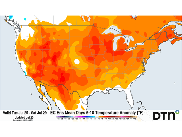
A heat ridge over the South, which has given rise to record temperatures from the Southwest through Texas and heat advisories and warnings across the southern tier of the country all week will do some shifting. During the next few days, the ridge will align more into the western United States and even poke up into Western Canada and spread out into the middle of the U.S. early next week. Temperatures will soar above normal with many locations in the 90s across the Corn Belt and some 100-degree readings likely in areas from the Northern Plains down through Texas. Triple-digit readings may be more sporadic than models are forecasting at the moment, but the heat will be on for next week. There are questions on the extent of the heat, though. States west of the Mississippi River and across the Gulf Coast are likely to be intense, but just how far east through the Corn Belt those 90-degree readings will extend is still to be determined. Ohio and Michigan are least likely to see the extreme heat of farther west as temperatures should more likely be in the 80s Fahrenheit most of the week, but a few days approaching or exceeding 90 F will be possible. High afternoon temperatures will not be the only issue, but warm overnight lows will also be a concern. Morning lows in the 70s F as far north as Nebraska to the southern Great Lakes will not allow for much relief overnight.
Part of the question about the extent of the heat will be strength of the heat ridge and potential for precipitation. The northern rim is usually a good spot to produce clusters of thunderstorms or even some systems. With a trough in the Gulf of Alaska expected to send some energy through Canada, we should see at least two systems move through the Canadian Prairies. Whether or not that means widespread precipitation in that region is still in the air as well.
P[L1] D[0x0] M[300x250] OOP[F] ADUNIT[] T[]
Models are not keen on too much precipitation over southern Alberta or Saskatchewan, but produce some as the disturbances ride over the top of the ridge across Manitoba and into the Great Lakes. As long as there are disturbances moving over the top of the ridge, there will be significant threats for severe thunderstorm clusters, bow echoes, and derechos.
The derecho of June 29 was one such ridge-riding storm cluster that produced needed rainfall, but also significant destruction. We have seen multiple clusters of varying intensity since then riding along the rim of the ridge. As that ridge has expanded and contracted, the northern edge has been a prime location for thunderstorms to occur.
This situation is likely to repeat itself, meaning at least some rainfall for areas that need it. But like the heat ridges so far this summer, south of the track of those thunderstorm clusters has been rough for developing crops. Crop conditions in Kansas and Missouri, even with recent rainfall, are not very good. Missouri has been especially troubled by hot weather as it took a while afterward to receive appreciable rain. The derecho of June 29 left Missouri in 100-degree heat for a few days. A return of similar conditions farther north could be more damaging, mostly because of the current stage of development of both corn and soybeans.
Corn is well into pollination and into the fill stage. Soybeans are blooming to setting pods. Moisture is at a critical point and with drought across much of the Corn Belt, there are few or no reserves for crops to rely upon for the upcoming heat. Any heat stress is going to be magnified for corn and will increase for soybeans should these conditions last deeper into August.
Models and DTN forecasts agree that the first half of August is likely to follow a similar pattern of overall above-normal temperatures and below-normal rainfall. That combination is a poor way to continue growing in dry soil.
The end of this pattern looks to come in mid-August by current model projections, with the ridge shifting back to the west and allowing a cooler trough to settle into the Great Lakes. That remains to be seen and the sooner that situation ultimately unfolds, the better for the Corn Belt.
To find more weather conditions and your local forecast from DTN, head over to https://www.dtnpf.com/…
John Baranick can be reached at john.baranick@dtn.com
(c) Copyright 2023 DTN, LLC. All rights reserved.

Comments
To comment, please Log In or Join our Community .