

Ag Weather Forum
Subsoil Moisture Deficits Continue Across Corn Belt
With rainfall going through the southern half of the Corn Belt last week, it appeared crop conditions were likely to improve when Monday's USDA Crop Progress report came out. However, we saw mixed conditions.
On a national level, good-to-excellent ratings for corn increased by 1 percentage point, while falling 1 point for soybeans and 2 points for spring wheat. On its face, it was hard to understand why, given how much rain fell from Nebraska to Kentucky and Tennessee. Widespread areas in this zone saw more than 2 inches, and many spots across the drought areas from central Illinois to Kentucky saw more than 4 inches. It was not a perfect zone, and larger areas of eastern Kansas and Missouri missed out, as did areas across the northern Corn Belt, especially Minnesota and Wisconsin. But with much of the I-states (Iowa, Illinois, Indiana) receiving some hefty totals, it was an overall disappointing report.
P[L1] D[0x0] M[300x250] OOP[F] ADUNIT[] T[]
Another factor to consider was the heat dome that developed over Texas and spread into Kansas and Missouri last week. Temperatures near or above the 100-degree Fahrenheit mark undoubtedly increased stress for portions of the southern end of the Corn Belt. That was the fuel for the eventual rainfall and severe weather that occurred in the area late in the week. But the two factors might have cancelled each other out a bit and a reason why crop conditions fell in both Kansas and Missouri despite some rains. Where the rain fell, the improvement to crop conditions was noticeable, but not extreme enough to wash out the drop in conditions across the far south, or the north where rainfall was scanter.
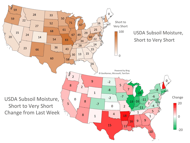
The more critical change occurred in the subsoil layer, as drought has been sapping what little moisture was stored there over the last few weeks. Storage of moisture below the top layer of soil had been very low and has not given crops a backup plan should a drier stretch emerge. Some areas saw noticeable improvements in the ratings of short-to-very short subsoil moisture where those rains have been more persistent and/or heavy. Illinois, Indiana, and Michigan all saw double-digit improvements to their short-to-very short categories (19, 16 and 20 points, respectively). But these states still show meaningful stress when it comes to the actual numbers that remain short to very short (67, 49, 67, respectively). Most other states in the Corn Belt have ratings greater than 40 percentage points except for North Dakota (33), Ohio (29), Kentucky (34), and Tennessee (28). Crops are still living very much hand-to-mouth when it comes to rainfall. And with crops nearing or entering reproductive stages, the rains need to keep coming to hold off further damage and fulfill lofty yield forecasts from earlier this year.
The pattern will at least stay active. A front moving through the Corn Belt this week will bring periods of rain to most areas, but anything heavy will be on the southern end of the front, especially as a system rides along it Friday through the weekend. Kansas and Nebraska through the Tennessee Valley are forecast to be the winners, while northern areas have been and will continue to see spottier showers. These southern states, including Kansas and Missouri that were wrecked by the heat last week, should see soil moisture improving again, while others to the north may not be as lucky. Some spotty areas could see improvements, but widespread moisture increases are not expected at this time. There will still be chances there, though.
A trough in Canada will send several fronts through the U.S. next week. Each has potential for showers, and if they can link up with disturbances coming out of the West, there could be some significant rains. Models have shied away from the disturbances in recent days, meaning more spotty rains with the fronts passing through. Thankfully, temperatures should remain mild, which would limit any stress outside of the far South like Texas and the Gulf Coast, though these areas may also see rain for the next week.
To find more weather conditions and your local forecast from DTN, head over to https://www.dtnpf.com/…
John Baranick can be reached at john.baranick@dtn.com
(c) Copyright 2023 DTN, LLC. All rights reserved.

Comments
To comment, please Log In or Join our Community .