

Ag Weather Forum
Exhausting Heat Dome Streak Continues in 2023
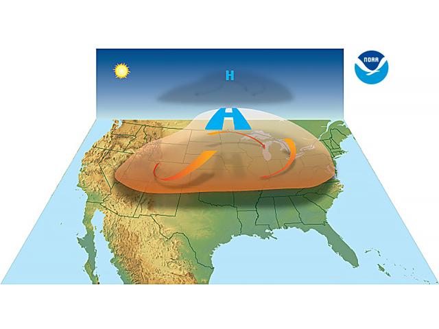
The U.S. is on a real hot streak over the past three years -- a streak of incredible heat domes, that is. Right around midsummer in the years 2021, 2022 and now 2023, a strong, stagnant area of high pressure has set up somewhere in the contiguous U.S. and produced record-breaking heat with crop damage, threats to livestock, and human fatalities. The Associated Press reports that as of Wednesday June 28, nearly a dozen deaths due to excessive heat had occurred in West Texas.
The heat domes show no real favorites in terms of location when they occur. Back in 2021, the Pacific Northwest got the heat; temperatures soared above 100 degrees Fahrenheit in May and June. In 2022, the heat dome started in the Northern Plains and then spread south and east; while, all the time, drought was exhausting crop moisture in the central and western U.S.
P[L1] D[0x0] M[300x250] OOP[F] ADUNIT[] T[]
The June 2023 heat dome impact on Texas furnished many details for the USDA Weekly Weather and Crop Bulletin on Tuesday, June 27: "Temperatures exceeded 110F in parts of central, western, and southern Texas, with some communities reporting all-time record highs," the report noted. "For example, San Angelo, TX, posted consecutive readings of 114F on June 20 and 21; previously, San Angelo had never experienced a high temperature greater than 111F. Elsewhere in Texas, all-time records included 115F in Laredo (on June 19) and Del Rio (on June 21). Previously, Laredo had also attained 115F on May 7, 1927; June 11, 1942; and Sept. 5, 1985. Prior to this year, Del Rio's highest readings had been 112F on June 9, 1988, and July 13, 2020 ... Midland achieved a high of 103F or greater each day starting June 15, including a daily-record high of 111F on the 21st. Even on the Texas coast, Corpus Christi logged a daily-record high of 103F on June 21."
The June 2023 heat dome had several immediate factors set up to produce the stalled high pressure that brought the heat, along with an overall pattern that spanned most of North America, according to Victor Murphy, NOAA Southern Region Climate Services Director headquartered in Fort Worth, Texas. "What stands out for me is the incredible blocky pattern that has changed little in the past month," Murphy told DTN in an email. "Strong troughs anchored over the west coast and east coast of the U.S., with the subtropical ridge in Mexico ... Of course, the biggest player of all has been the persistent ... ridge over Hudson Bay that has simply dominated the eastern 2/3 of Canada and accounted for all their fires."
An interesting facet of this particular heat dome is that it set up over Texas even though much of the state had good rainfall in late spring. "One thing that is a little unusual about this heat wave is we had a fairly wet April and May, and usually that extra moisture serves as an air conditioner," Texas State Climatologist John Nielsen-Gammon told the Christian Science Monitor. "But the air aloft is so hot that it wasn't able to prevent the heat wave from occurring and, in fact, added a bit to the humidity."
Forecasts call for the big heat dome to moderate during early July. But in addition to its deadly features, the heat dome has also caused record electrical usage, and spread its harsh influence into the southern Midwest and the Southeast. We don't know yet to what extent corn and soybeans going through their reproductive phases will be hurt by the heat, but it's sure to cause some concern in midsummer assessments of harvest prospects for this year.
(c) Copyright 2023 DTN, LLC. All rights reserved.

Comments
To comment, please Log In or Join our Community .