

Ag Weather Forum
El Nino Taking Longer to Influence Weather Pattern

The Climate Prediction Center changed the official status from an El Nino Watch to an El Nino Advisory on June 8. That meant that El Nino was being observed in the equatorial Pacific Ocean and was expected to last for at least the next three months.
The central Pacific is on pace and the atmosphere is changing, but the expectations for better weather across America's Corn Belt have yet to materialize.
I previously wrote about the developing climate phenomenon back in April and you can read more about it here: https://www.dtnpf.com/….
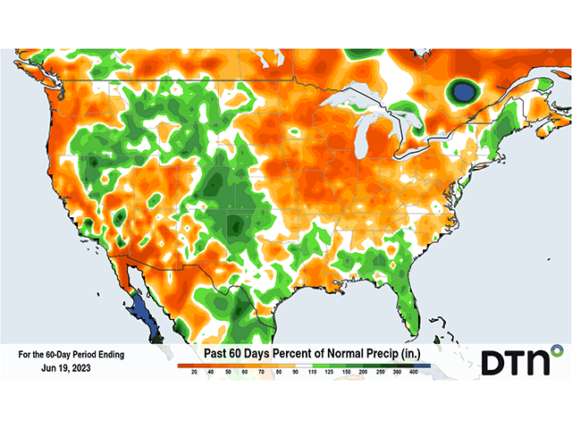
Stagnant patterns and the development or maintenance of drought in much of the Corn Belt have been the results over the last several weeks. It has been very hard to get significant rains over too many areas, especially in the highest-producing states of Iowa and Illinois. The previous 60-day precipitation anomalies tell the story, with widespread rainfall deficits in the country's Corn Belt.
One area that has benefited from the stagnant pattern has been the High Plains. Rainfall has been consistent, soils have filled up with water and drought has been significantly reduced. But it has taken a long time to get rid of. After three winters of La Nina and two summers of significant drought, it has been tough to completely eliminate the drought.
And La Nina's long-term effects do not end there. The opposite of El Nino, it is when sea-surface temperatures in the middle of the Pacific Ocean are colder than normal. Instead, strong easterly winds around the equator push the warm waters westward to the so-called "Maritime Continent" region, the major archipelago that consists of Indonesia, Malaysia and the Philippines, among other islands. That large pool of warm water there is having a tough time letting go and it is influencing the pattern.
P[L1] D[0x0] M[300x250] OOP[F] ADUNIT[] T[]
In a conversation with DTN Long-Range Weather Risk Analyst Nathan Hamblin, this pool of warmer water has been a significant reason why the atmosphere is holding back the remnant effects of La Nina, and why the pattern has not quite lived up to the expected favorable conditions.
"The building features of El Nino are slowly eating away at that pool of warmer water in the Maritime Continent region, but the process has been slow," Hamblin said. "The tropical forcing coming out of that region favors an eastern U.S. trough, which has kept the Midwest dry."
The process has been slow, but it is starting to change. A ridge of high pressure has bumped up from Mexico and into Texas. While that has baked the state with triple-digit heat, it has forced the jet stream, and subsequent storm track, a bit farther north than the Southern Plains-to-Southeast track that has been favored in recent weeks.
A block across Hudson Bay has kept the Midwest dry this week, but it will weaken at the end of the week and shift more to eastern Canada, which creates a larger channel for disturbances to move from the West to the East, largely through the Corn Belt. One system will be taking that track this weekend and is forecast to produce heavy rainfall for large portions of the Northern Plains and northern Minnesota, areas that have recently become very dry. The coverage of the rainfall through the eastern half of the Corn Belt is less certain, however. Still, it's the best chance to get rainfall into the northern half of Illinois in the past couple of weeks, even if models are not keen on producing a lot in that area specifically.
"Models are not favoring the central Midwest with much rain," Hamblin noted. "Coverage and amounts are pretty low." But that does not mean that some areas in this region will not get some good rainfall. The system will be bringing scattered thunderstorms through, and models are not very good at handling thunderstorms, even when connected to a well-forecast system.
Still, this is just the first in a line of disturbances that look like they may make it through this channel over the coming weeks. Hamblin noted that another system next week looks more promising for the Corn Belt when looking at them as a group, what are known as ensembles.
"That week-two timeframe does get some better rainfall in there on several of the ensembles" he added. "The track is shifted a little bit better." He does note that there will still be haves and have-nots out of this system. Disturbances that follow going through early or mid-July will have the same issues. Some areas will receive needed rainfall, others will not. And models tend to suggest that more areas will receive below-normal rainfall, even in this more-active pattern.
This is not a good time for below-normal rainfall. On a national level, corn and soybean conditions fell again this week and are now the lowest since 1988 for corn and 1996 for soybeans. You can read more about crop conditions here: https://www.dtnpf.com/…. With corn pollination coming up in a couple of weeks and corn already stressed with more poor weather this week, rainfall cannot come soon enough, and likely not heavy enough, to stave off damage across major production areas in the country.
Subsoil moisture ratings from the latest USDA report show short-to-very short ratings at greater than 50% for most states in the Corn Belt outside of North Dakota (43%), Minnesota (45%), and Ohio (42%). Illinois is at 83% and Michigan is at 89%. There is just no significant moisture for crops to handle any further dry stretches. The rain needs to come, and it needs to come now. But some areas are going to miss out.
What is it going to take and how long to get into the preferred weather pattern that many forecasters, including myself, were expecting earlier this year? Hamblin says hopefully in another month. "Two things can happen," he said. "We could see the Bermuda high strengthen and push the eastern trough to the middle of the country, or we need to get the pool of warmth in the western Pacific to erode away." And that Bermuda high has no significant hope of strengthening anytime soon. That means that El Nino will keep doing its business by changing the global weather pattern, but at a slower pace.
"By late July, we should be seeing a more productive El Nino pattern, which should make for some good late-season rains," Hamblin said. "Outside of a lucky thunderstorm complex that brings widespread precipitation through the Corn Belt next week, this region is largely going to have below-normal rainfall for a while yet."
Corn cannot wait that long. These rains that come through are going to have to come through at the right time to produce decent conditions and keep them from getting worse. Even below-normal rainfall can be favorable if it comes at the right time. Producers in the middle of the country are holding out hope. Those with soybeans are still holding on for a more productive pattern in August to bring the needed rains, as that is the most critical time. That is, of course, as long as the plants are still in decent shape come August.
To find more weather conditions and your local forecast from DTN, head over to https://www.dtnpf.com/…
John Baranick can be reached at john.baranick@dtn.com
(c) Copyright 2023 DTN, LLC. All rights reserved.
Comments
To comment, please Log In or Join our Community .