Ag Weather Forum
Illinois Is Drying Up Quickly
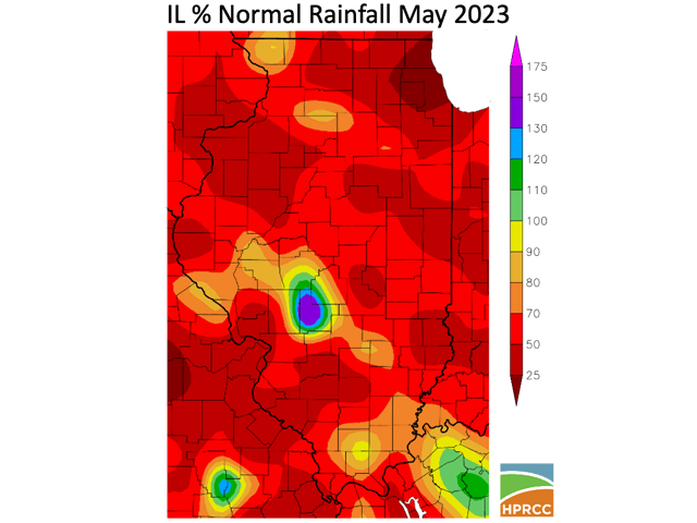
Illinois, the No. 2 state in U.S. corn production and the No. 1 state in U.S. soybean production, is quickly running out of moisture. The combined statewide average rainfall in April and May was 5.51 inches, 2.94 inches or 35% below the normal 8.45-inch total. (Details are from the USDA Illinois state crop report.) But, within that statewide average, there are areas which were even drier. At the National Weather Service (NWS) office in Chicago, the total May rainfall amounted to 0.71 inches -- 3.78 inches below the normal 4.49 inches (84% below normal). In fact, the Chicago NWS location was even drier in May of this year 2023 than in May of the harsh drought year 2012; the last time that May precipitation failed to reach the 1-inch mark was back in 1994.
This lack of rainfall shows up in soil moisture rates. In early May, topsoil moisture was rated only 26% short to very short and subsoil moisture had a short to very short total rating of just 18%. But by the end of the month, the short to very short ratings totals jumped to 42% for topsoil moisture and more than doubled to 37% short to very short for subsoil moisture. The ground is getting dry.
Robust upper-atmosphere high pressure over north-central Canada gets the biggest share of attribution for this chronic Illinois dryness -- which is also spreading through the Midwest. Weather charts show the Canadian high's expanse as far south as west-central Illinois. A dry northerly air flow has prevented any significant inflow of moisture from the Gulf of Mexico into the Midwest, hindering the formation of storms and precipitation.
P[L1] D[0x0] M[300x250] OOP[F] ADUNIT[] T[]
Looking to the balance of this first half of June, rainfall forecasts do not bring more than scattered light amounts into the state -- certainly not enough to alter this net-drier pattern. DTN city forecasts through June 18 suggest no more 1-inch total precipitation in a 14-day period -- an average of less than one-tenth inch per day. At the same time, calculated evapotranspiration (moisture loss through water evaporating from the soil and by transpiration from plants) is almost 0.25 inches per day for a total of more than 3 inches in the 14-day period. This deficit in precipitation, along with increasing crop demand for moisture ahead of corn pollination and soybean flowering, will keep concern high over whether Illinois crop output can match the typical top or near-the-top corn and soybean levels again in 2023.
DTN Ag Meteorologist John Baranick has more commentary on Midwest drought development in his article, "Dryness and Drought Increasing Across the Midwest," that can be found at https://www.dtnpf.com/….
To find out how the USDA is reacting to the drought, check out when USDA puts out its World Agricultural Supply and Demand Estimates (WASDE) on Friday. DTN will have coverage of that event later this week. Join us Friday at 11 a.m. CDT for coverage of the June WASDE report. At 12:30 p.m., DTN Lead Analyst Todd Hultman will review details of the report in his monthly webinar. You can sign up for that webinar here: https://www.dtn.com/… and also keep an eye out later this week for DTN's reports preview and post-report coverage and analysis.
If you missed it, see DTN's recent story on the "Five Signs of Early-Season Drought Stress" at https://www.dtnpf.com/….
To find more weather conditions and your local forecast from DTN, go to https://www.dtnpf.com/….
Bryce Anderson can be reached at Bryce.anderson@dtn.com
(c) Copyright 2023 DTN, LLC. All rights reserved.


