

Ag Weather Forum
A Recap on Last Week's Heavy Rainfall

Last week had the perfect setup to produce batches and blotches of heavy rain across the middle of the country, and across areas that had been missed recently.
A ridge of high pressure took over most of North America, increasing temperatures and pumping in moisture from the Gulf of Mexico. At the same time, an upper-level low-pressure system moved into the Southwest. At first, it sent a few waves of energy into the ridge, which produced clusters of thunderstorms and localized heavy rain. But, eventually, it drifted into the Plains on May 11 and stuck around through the weekend. A secondary low formed over Texas and has been drifting north into the Ozarks since then, producing more areas of heavy rain.
P[L1] D[0x0] M[300x250] OOP[F] ADUNIT[] T[]
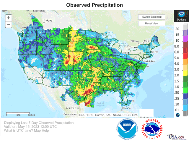
In the attached image, you can see the results of a week-long assault from the atmosphere. Widespread areas of moderate and heavy rain ran through the Plains, Midwest, Delta, and parts of the Southeast and Mid-Atlantic. Areas in yellow received over 2 inches of rainfall in that time; this fell over some of the drought areas that have been plaguing the middle of the country for the last couple of years. In particular, the area that stretches from northeast Colorado and far northwestern Kansas, north through eastern Montana and the western Dakotas was the area that benefited the most from last week's rainfall. However, there were many areas from southern Minnesota to Tennessee and from southern Missouri through parts of Texas that also received beneficial heavy rainfall. Undoubtedly, there should be large reductions in drought when the U.S. Drought Monitor updates on Thursday morning.
Not all areas received the needed rainfall. Parts of eastern Nebraska, central Missouri and Illinois, and the southwestern Plains received less than an inch, which does not keep up with normal weekly rainfall amounts. However, this turned out to be an overall good week of rainfall across much of the country's drought areas and increased soil moisture for crops and forages.
The rain did not come without issues. Some areas received too much rain and areas from Colorado and western Nebraska to southern Minnesota and parts of Texas and Oklahoma had issues with flooding as more than a month's-worth of rain fell in a short period of time. Severe storms were also an issue. Several days of hail and strong winds preceded an increase in tornadoes as the upper low drifted through Nebraska and Iowa. DTN Staff Reporter Russ Quinn will have more about the tornado damage that occurred in eastern Nebraska on May 12 in a later story on dtnpf.com.
And the rain is not done just yet. That new upper low over the Ozarks continues to produce widespread rain for the southern half of the country through Wednesday and a front dropping south from Canada will bring more widespread showers and thunderstorms Wednesday into the weekend across the country east of the Rockies. These rains may fill in some places that missed out on last week's rainfall, including those areas in southwestern Kansas and the Texas and Oklahoma Panhandles where only spotty showers occurred.
To find updated radar and analysis from DTN, head over to https://www.dtnpf.com/…
John Baranick can be reached at john.baranick@dtn.com
(c) Copyright 2023 DTN, LLC. All rights reserved.
Comments
To comment, please Log In or Join our Community .