

Ag Weather Forum
February Weather Forecast Now Looking Milder in Spite of La Nina
We almost made it through an entire month of above-normal temperatures in January, but the polar vortex would not let us go without a punch of cold across most of the country. This one is a short-duration event and though it will be bleeding into the first few days of February, the month will look somewhat similar to January. That is, at least east of the Rockies.
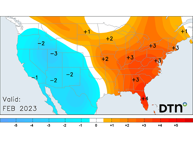
This pattern is not very consistent with what we would expect historically for a La Nina-controlled February. La Nina occurs when sea-surface temperatures in the tropical Pacific Ocean are below normal. Overall for February, areas west of the Rockies are forecast to be cooler and drier, except in the Pacific Northwest which may be near or slightly above normal for precipitation. East of the Rockies, the Prairies and Plains will be a battleground of temperatures and precipitation, but favoring warmth over coolness while the East is warm and wet. Of course, in a months-worth of weather, this pattern is only general and there will be some variation in it. This forecast is different than the forecast of a month ago, when the pattern was favoring more of a clipper-pattern across the North-Central U.S. and Canada where cooler conditions were forecast -- which is historically more like a La Nina February.
We could see some other changes as we move deeper into the month as well, but that is what the long-range weather patterns are showing us today.
In January, the main weather pattern was a trough off the West Coast with a broad ridge through North America. The ridge was not particularly strong, so the weather pattern ended up fairly active, leading to widespread precipitation across the West and California in particular, along with eastern Texas and Oklahoma through the East Coast.
The only area to really escape any significant winter storm was in the southwestern Plains where only an event or two produced widespread precipitation for western Kansas down through western Texas. Even though these areas got their normal amount of rain for January, it was not nearly enough to have any impact on the long-standing drought.
P[L1] D[0x0] M[300x250] OOP[F] ADUNIT[] T[]
February's pattern is going to look a bit different, but the effects for the eastern half of the country may look the same. The weather pattern is in flux at the moment, with the polar vortex that brought the cold air for this week set to move off into the North Atlantic this weekend. A ridge of high pressure off the West Coast will move east and a couple of troughs will follow in its wake, producing some storm systems for early February. The ridge that slides eastward will fill North America with warmer, pacific air. The troughs that follow it will have only marginally low temperatures with them.
Eventually, the pattern will settle into one with a trough of low pressure in the West and a ridge of high pressure in the East, particularly in the Southeast U.S. That promotes lower temperatures west of the Rockies, and warmer conditions east of the mountain range. Another big change will be what happens for the Arctic.
According to DTN Long-Range Weather Risk Communicator Nathan Hamblin, the first half of February will feature "a trough of low pressure near Alaska, which will cut off arctic air from North America." That will keep North America warm through the first half of the month, after the polar vortex moves out later this week.
We may see some change to that in the latter half of the month. Hamblin noted the movement of the Madden-Julien Oscillation (MJO), or a zone of convection that moves along the equator, will be a factor throughout the month. The MJO is forecast to move from Indonesia toward the central or eastern Pacific Ocean. When this occurs, temperatures in February for the eastern half of North America can take a dive as a trough of low pressure is favored over the middle of the continent -- but only if the convection is strong. If it is weak, the warmth east of the Rockies would likely continue. Until then, the trough will remain out in the West.
Having a trough out in the West with a ridge in the East promotes a storm track through the middle of North America, bringing storm systems through the West, particularly the Pacific Northwest U.S. with good precipitation, and then from Colorado or Wyoming up through eastern Canada.
At times, lower temperatures leak into the Canadian Prairies and U.S. Great Plains. But being of Pacific origin, the anomalies are not tremendously low. Meanwhile the eastern states and Canada stay warm and wet. Moisture is pumped north from the Gulf of Mexico to feed some heavier precipitation for the far eastern Plains and points eastward as the storm systems move through. Fronts typically stall out near the Ohio River under these scenarios, which will help focus higher precipitation anomalies there.
Even with this more active pattern, the southwestern Plains is usually left out and drought is expected to continue.
To find updated radar and analysis from DTN, head over to https://www.dtnpf.com/…
John Baranick can be reached at john.baranick@dtn.com
(c) Copyright 2023 DTN, LLC. All rights reserved.

Comments
To comment, please Log In or Join our Community .