

Ag Weather Forum
Extreme Temperature Drops This Week Because of Polar Vortex

A visit from the polar vortex was forecast well in advance of its arrival this week. The rapid drop in temperatures might have caught some people off-guard during the last couple of days, but forecasters and government officials were spouting dangers of its arrival days in advance. Folks had plenty of time to prepare their homes and adjust their travel plans for the incoming cold so as to avoid serious disruptions to the holiday week, but that did not mean the cold did not hurt coming through.
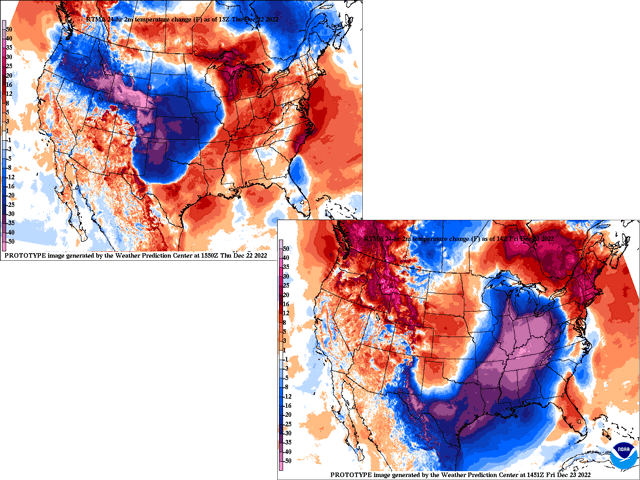
Very cold weather from the North Pole was reinforced by snow cover over Western Canada and the Northern Plains early this week before taking a sweep through the United States Dec. 21-22. Temperatures dropped very quickly, in most cases more than 40 degrees from where they were the day before, and usually within a 12-16 hour span of time.
The more extreme examples are in the central and southern High Plains, where winds coming off of the Rocky Mountains briefly warmed the air before the arctic front came through. Significant drops also occurred in the eastern Midwest where warm air was drawn northward before the front passed. The Northern Plains were already cold before the arctic blast came in. Southeastern areas of the country have also seen extreme temperature drops, but the drop was more gradual over time rather than a very quick and sharp drop. Here are a few examples of significant temperature drops during the last couple of days, at their local times.
-- Casper, Wyoming: 70-degree temperature drop from 28 degrees Fahrenheit at 7 a.m. Wednesday, to minus 42 F at 2 a.m. Thursday. Includes a 34-degree drop in one hour early Wednesday.
-- Denver: 75-degree drop from 51 F at 2 p.m. Wednesday, to minus 24 F at 8 a.m. Thursday. Includes a 37-degree drop in one hour Wednesday afternoon.
-- Amarillo, Texas: 63-degree drop from 61 F at 3 p.m. Wednesday to minus 2 F at 7 a.m. Thursday. Includes a 30-degree drop in one hour Wednesday night.
P[L1] D[0x0] M[300x250] OOP[F] ADUNIT[] T[]
-- Oklahoma City: 41-degree drop from 43 F at 5 p.m. Wednesday to 2 F at 11 a.m. Thursday.
-- Houston: 43-degree drop from 58 F at 12 p.m. Thursday to 15 F at 7 a.m. Friday.
-- Little Rock, Arkansas: 44-degree drop from 46 F at 12 p.m. Thursday to 2 F at 6 a.m. Friday.
-- Memphis: 44-degree drop from 45 F at 3 p.m. Thursday to 1 F at 3 a.m. Friday.
-- Chicago: 41-degree drop from 33 F at 11 a.m. Thursday to minus 8 F at 7 a.m.
-- Indianapolis: 50-degree drop from 41 F at 4 p.m. Thursday to minus 9 F at 7 a.m. Friday.
-- Louisville, Kentucky: 53-degree drop from 47 F at 3 p.m. Thursday to minus 6 F at 6 a.m. Friday.
-- Columbus, Ohio: 51-degree drop from 44 F at 11 p.m. Thursday to minus 7 F at 10 a.m. Friday.
-- Huntsville, Alabama: 49-degree drop from 51 F at 6 p.m. Thursday to 2 F at 8 a.m. Friday.
As of mid-Friday morning, temperatures were still dropping along the East Coast, but some similarly fast temperature drops are expected during the day.
To find updated radar and analysis from DTN, head over to https://www.dtnpf.com/…
John Baranick can be reached at john.baranick@dtn.com
(c) Copyright 2022 DTN, LLC. All rights reserved.
Comments
To comment, please Log In or Join our Community .