Ag Weather Forum
Heavy Rain Floods Illinois
Heat has been building in the Plains and is spreading its way eastward through the Midwest. On the edge of that heat, thunderstorms developed late Monday across Illinois. Storms trained, or continually moved over the same areas, Monday night through midafternoon on Tuesday.
This training mechanism can happen in several ways. In this case, the thunderstorms forming on the edge of the heat on Monday developed a pool of cooler air at the surface that enhanced the warm front from northwest to southeast Illinois. Winds not far above the surface were mostly parallel along that boundary, meaning that instead of storms pushing eastward, away from the surface boundary, they continually moved along it, enhancing it throughout Tuesday morning. Eventually, on Tuesday afternoon, the upper-level winds shifted direction and the storms were cut off and dissipated.
P[L1] D[0x0] M[300x250] OOP[F] ADUNIT[] T[]
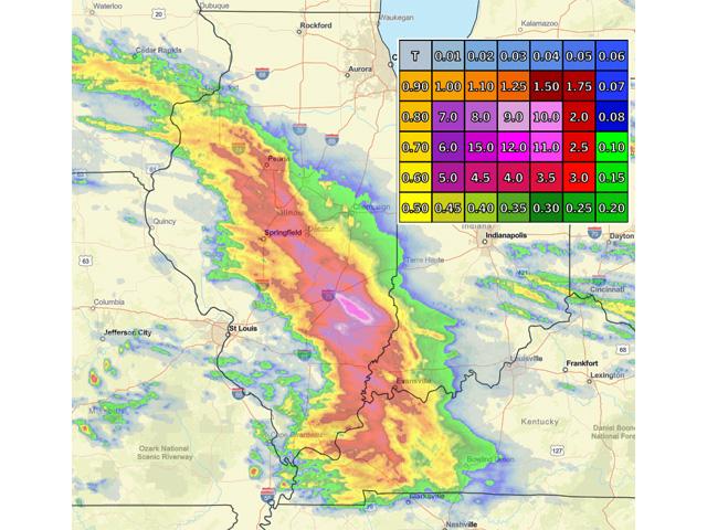
What occurred then was a stripe of heavy rainfall across the state with widespread amounts over an inch and a half. In the accompanying image that is based on satellite and radar estimates, that is in the red shading. A little harder to see were also many areas that received over 5 inches of rain in purple. In the pink shading, a small area in southeast Illinois from Effingham to Richland counties received an estimated 10 to 12 inches. While amounts that high may have been received, there are no reports to back up those extreme totals. However, the National Weather Service in Lincoln, Illinois, did receive widespread reports of over 2 inches and several over 4 inches.
While these rains did occur over about a 24-hour period and some places should have been able to handle the rainfall without too much damage or flooding, lower spots, areas with denser soils or no tiling, and the areas of extreme rain over 5 inches likely are having troubles.
Of course, the rains are coming at a critical time for corn and soybeans while they are filling, but too much rain and flooding are not ideal. These areas have more chances for moderate to heavy rain Wednesday and Thursday, which could exacerbate the flooding issues.
To find updated radar and analysis from DTN, head over to https://www.dtnpf.com/….
John Baranick can be reached at john.baranick@dtn.com
(c) Copyright 2022 DTN, LLC. All rights reserved.


Comments
To comment, please Log In or Join our Community .