Ag Weather Forum
Drought in Canadian Prairies at Lowest Coverage in Almost Two Years
Drought has been a common theme in the Canadian Prairies during the last two years. Since summer of 2020, a lack of rainfall had produced significant moisture reductions that have led to drought conditions across much of the region. It has varied during the course of the rest of 2020 and through 2021, but we finally started to see a reprieve in the conditions during the winter into 2022. A clipper pattern set up over the winter that continued to track storm systems through the region.
While northern farming areas saw most of the precipitation and drought reduction, 2022 was not done yet. In spring, several large, wound-up systems produced significant heavy rain and snow for the eastern sections of Saskatchewan and through Manitoba, eliminating drought and instead causing concerns with flooding and muddy or ponded fields. This summer, the pattern has changed again, and has now given more moisture to southwestern growing areas that had been very concerned about dryness and drought for the start of the growing season.
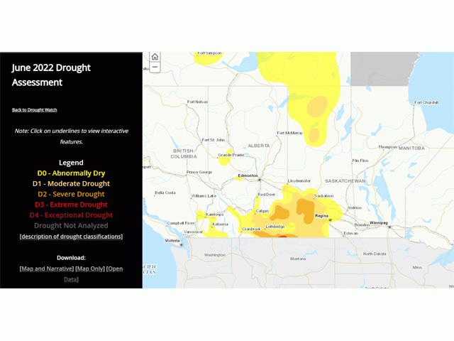
As of the latest drought monitor released by Agriculture and Agri-Food Canada (AAFC) on July 12, drought is now confined to a small area in the southwestern Prairies and the month of June saw the elimination of any areas of D3, or extreme, drought. Currently, just 39% of the agricultural land is covered in some form of dryness or drought, down from 100% since the start of the year.
In fact, the map for the end of June 2022 is the first map since February of 2021 where there have been no areas of D3 drought in the region. And we have to go back to the end of July of 2020 to find a time when less of the Prairies were covered in some form of drought. It was that month when the weather started to become uncooperative and dryness started to increase across the region and producers were getting worried about their 2020 crop finishing in dryness.
Through August 2020, conditions only deteriorated and D0 or D1 drought had covered approximately 60% of the Prairies agricultural land. Drought expanded significantly through 2021, and especially in June and July, leading to low agricultural output for much of the region.
P[L1] D[0x0] M[300x250] OOP[F] ADUNIT[] T[]
This season has had its hardships as well, and weather is never a constant, but conditions this year are far better. That includes looking forward for the rest of the season. A ridge of high pressure in the upper atmosphere has been very limited across the region this season. Ridges cause hot and dry conditions, unfavorable for crops or livestock.
But around its edges, we find active weather and overall good growing conditions with mixed temperatures. Bursts of heat are followed by periods of showers and days of relief without conditions getting too cold. It is almost a "Goldilocks" scenario of getting frequent enough rain but plenty of sunshine and occasional heat to foster growth. As long as the ridge stays over the U.S., the Prairies will continue to be in the "Goldilocks" zone.
Forecasts are pointing to that being the case through at least mid-August if not beyond. That is good enough to last the rest of the growing season for the shorter-season crops and most of the longer-season varieties that were able to be seeded in the east.
There is still a way to go for eliminating the drought in the southwestern Prairies and they are still in need of some moisture. Although drought was reduced overall in the region, there were areas of south-central Saskatchewan that did see drought increasing in the month of June. Showers earlier in July have missed more of these areas than they hit, although other portions in drought in southern Alberta and southwest Saskatchewan did see better precipitation. But the forecast during the next week does offer another chance.
A trough will move along the northern edge of the ridge through the region. Until yesterday, the forecast was for the storm center to go through Central Alberta and straight eastward. It would have clipped some of the drought areas, but not many, and also left some higher temperatures into those southern areas.
But the storm track has shifted a bit farther south since then, bringing the low center through southern Alberta and points eastward. This would bring more widespread moderate to heavy rainfall to more of the drought areas. With an active rest of the month and more chances for rainfall here and elsewhere, there could be little drought plotted in the Canadian Prairies on drought monitor released next month.
In fact, in AAFC's outlook for drought, they have drought improving or being eliminated for almost the entire growing areas of the Canadian Prairies. That was put out before this change in the forecast.
It may have taken a while to turn things around, but drought reduction this year has certainly been a blessing for most of the Prairies, even if it has come with flooding and delayed seedings for those in the east.
To find more international weather conditions and your local forecast from DTN, head over to https://www.dtnpf.com/…
John Baranick can be reached at john.baranick@dtn.com
(c) Copyright 2022 DTN, LLC. All rights reserved.


Comments
To comment, please Log In or Join our Community .