Ag Weather Forum
La Nina Dominated Spring Weather Patterns
I recently traded in the forecast desk for the tractor cab for a few days on my family's farm operation in southwest Minnesota. Like most operations across the Northern Plains and Upper Midwest, we've spent the planting season playing catch-up as an active weather pattern persisted, bringing widespread rain showers and lower temperatures.
This spring has proved challenging for producers across the United States, with the cool phase of the El Nino-Southern Oscillation, La Nina, dominating the weather pattern. But now that the meteorological spring is past us, I thought I'd take some time to give a recap of dominant weather conditions experienced across the U.S. this spring.
Beginning with the month of March, above-average precipitation dominated across portions of the Upper Midwest, Central Plains, and Upper Mississippi Valley. Outside of these regions, the Northern and Southern Plains, Ohio Valley, Tennessee Valley, and much of the western half of the U.S. saw below-average precipitation.
An early start to the planting season looked dismal across the north-central U.S. with blasts of cold, arctic air during the middle of March and rounds of rainfall across an already wet Eastern Corn Belt toward the end of March.
P[L1] D[0x0] M[300x250] OOP[F] ADUNIT[] T[]
However, the south-central U.S. was dealing with quite the opposite problem. Much of the Central and Southern Plains were at a high risk for wildfires during March while receiving very little in the way of widespread, soaking rainfalls to help boost topsoil moisture. Coinciding with the wetter conditions, cooler-than-average weather held on across the central U.S. Outside of the central U.S., above-average temperatures gripped the west and east.
Looking at April, the anomalously high precipitation pattern shifted northwest to the Northern Plains and portions of the Upper Midwest. A few late-season snowstorms burying the Northern Plains and Northern Great Basin are to thank for lending to the above-average precipitation. One such notable snowstorm occurred April 12-14, where locations across North Dakota reported 1-2 feet of snow.
On the other hand, below-average precipitation creeped a bit farther north into the Central Plains, Central Mississippi Valley, and portions of the Great Lakes. This low precipitation also maintained its presence across the south-central U.S., Tennessee Valley, and Ohio Valley. Besides rounds of severe thunderstorms moving across the south-central U.S. during April, many of the storms failed to provide widespread topsoil moisture for freshly planted corn and maturing winter small grain.
As for temperatures, a more definitive pattern in temperature anomalies arose in April across the U.S. If you drew an east-west line from Virginia to northern California, temperatures north of this line were below normal while temperatures south of this line were above normal.
May introduced different precipitation and temperature patterns across the U.S. Above-average precipitation fell across the Central Plains and Upper Mississippi Valley, while below-average precipitation started to spread across the Northern Plains and Upper Midwest, allowing more windows of opportunity to get crops planted, especially later in the month.
Right off the bat, the first week of May featured rounds of thunderstorms accompanied by more widespread precipitation across the Central and Southern Plains, helping to slightly relieve drought conditions. Yet, steady rounds of rainfall kept swinging through the north-central U.S. throughout May, giving only small periods of time to get corn and soybeans planted. Outside of the central U.S., portions of the Pacific Northwest and the Southeast U.S. saw above-average precipitation while the Ohio Valley and Tennessee Valley held onto below-normal precipitation.
Looking at the temperature anomalies, much of the eastern and south-central U.S. saw above-average temperatures while below-average temperatures covered the Northern Plains, much of the Great Basin and the Pacific Northwest.
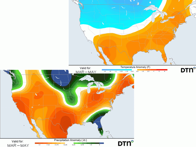
Overall, this spring provided the wettest and coolest conditions to the Northern Plains while the driest and warmest conditions were concentrated across the Southern Plains. Regardless of the rather active and challenging weather pattern producers have had to face, there are still some uncertainties regarding the weather pattern going into the summer and the remainder of the growing season.
If you're curious about what the first half of the growing season may entail for your region, I encourage you to check out what DTN Ag Meteorologist John Baranick's thoughts are. His article can be found here: https://www.dtnpf.com/….
To find more regional weather conditions and your local forecast from DTN, head over to https://www.dtnpf.com/…
Teresa Deutchman can be reached at teresa.deutchman@dtn.com
(c) Copyright 2022 DTN, LLC. All rights reserved.


Comments
To comment, please Log In or Join our Community .