
Ag Weather Forum
Midwest Derecho Possible June 13 as Storms Forming

Early in the morning on June 13, thunderstorm clusters have formed over southern Minnesota and Iowa. With a warm front lifting north through the Midwest and a mid-level disturbance riding along the front, conditions are coming together to produce a potentially strong thunderstorm event from southern Wisconsin, northern Illinois and points southeast through Ohio throughout the day. If conditions and development comes together perfectly over a long stretch, the term derecho may describe today's event.
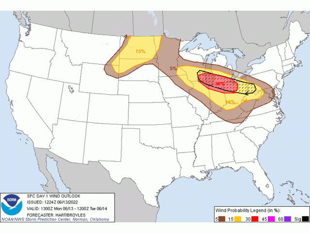
The Storm Prediction Center has an "enhanced risk" (three out of five) of severe thunderstorms across this area as of 8 a.m. CDT, though they left open the potential to increase this risk as the day progresses. Their main concern is with a line or clusters of storms continuing from Minnesota and Iowa southeastward producing strong wind damage and a few tornadoes.
P[L1] D[0x0] M[300x250] OOP[F] ADUNIT[] T[]
Heat south of this front is going to be intense during the day. High levels of moisture south of the front will stream northward into the front as well, feeding storm potential this afternoon and evening across the region.
If storms can put down a pool of cold air and ride the front southeast as forecast by many short-range models, then a line or couple of clusters of damaging wind gusts would be possible, along with some large hail and a few tornadoes. Such a long-tracked storm could be labelled a derecho if wind gusts reach hurricane strength (74 miles per hour or greater) along a line of continuous damage at least 250 miles long. That certainly seems possible given the setup for today.
Those along and near this zone of potential should pay close attention to weather and authorities when severe thunderstorm or tornado warnings are issued.
For tips for farmers on how to prepare for extreme weather events, including windstorms, see: https://www.dtnpf.com/….
To find updated radar and analysis from DTN, head over to https://www.dtnpf.com/….
John Baranick can be reached at john.baranick@dtn.com
(c) Copyright 2022 DTN, LLC. All rights reserved.
Comments
To comment, please Log In or Join our Community .