Ag Weather Forum
Prevented Planting Scenarios Possible With Recent Weather Patterns
A weather pattern that has turned some high-production crop areas of the northern United States from too dry to too wet is also leading to thoughts of growers being forced to take prevented planting insurance payments instead of dealing with delayed planting and a crimped growing season.
The bull's-eye of this situation is in North Dakota. The USDA Weekly Weather and Crop Bulletin posted Tuesday, April 19, noted, "In North
Dakota, April 12-14 snowfall included 12.6 inches in Grand Forks
P[L1] D[0x0] M[300x250] OOP[F] ADUNIT[] T[]
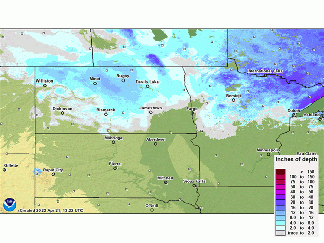
(National Weather Service office) and 18.3 inches in Bismarck. Storm total snowfall topped 2 feet in several North Dakota communities, including Velva (28 inches), Lansford (27.5 inches), Dunn Center (26 inches), and Underwood (24.3 inches)."
A week after the heavy snow, snow cover estimated on April 21 still totaled more than a foot deep in central and north-central North Dakota. In addition to the heavy snow, winterlike temperatures brought harsh cold to the region. Bismarck recorded its latest-ever reading of zero degrees Fahrenheit or below, and its coldest April weather since 1996, with temperatures of minus 1 F on April 5. And by April 16, snow-covered areas of North Dakota had widespread single-digit Fahrenheit low temperatures; Minot and Grand Forks both posted lows of 8 F.
This cold and wet combination can be attributed to two large-scale atmospheric features -- the continued influence of La Nina in the equatorial Pacific, and the development of persistent upper-atmosphere high pressure in the far northern latitudes. La Nina features storm tracks focusing over the northern U.S. along with a higher probability of precipitation. This is especially evident during the winter season. During spring, a generally warmer trend moves the jet stream northward, but that northward re-orientation is stalled -- blocked -- by the far Northern Hemisphere high pressure influence. DTN long-range forecaster Nathan Hamblin pointed this out in an e-mail discussion. "I think what you are seeing is an early trip north of the jet stream during the spring months and it suddenly gets halted because of the presence of high latitude blocking," Hamblin said.
Blocking high pressure is nothing new in the last 10 years or so, noted Hamblin. Growing seasons in 2019 and 2020 -- which featured many prevented planting acreage claims in the northern U.S. -- had similar occurrences of blocking high pressure. "I would say yes, especially in 2019," Hamblin said. Ridging (high pressure) east of Alaska through Greenland was prevalent. In 2020, there was ridging near Alaska and ... from Europe to almost Greenland."
The spring planting time frame has notably shrunk because of this cold and wintry pattern. April is the primary month for spring wheat planting; that operation is stranded by snowdrifts. Other crops with a northern U.S. focus such as oats, sugar beets, sunflowers and barley are also lagging in their planting progress.
Latest 30-day forecasts offer very little improvement in the overall temperature pattern. Most of the northern and central U.S. are slated to have below-normal temperatures during May as the double play of La Nina and blocking high pressure continue their influence. In the north country, the time walls of the shorter growing season are already starting to close in.
Bryce Anderson can be reached at Bryce.anderson@dtn.com
Follow him on Twitter @BAndersonDTN
(c) Copyright 2022 DTN, LLC. All rights reserved.


Comments
To comment, please Log In or Join our Community .