

Ag Weather Forum
When Does This Clipper Weather Pattern End?
During the last couple of months, I think I have used the word "clipper" more than I have in my life. It seems we have continued to be in the pattern that favors these types of systems for quite some time. I point back to the last half of December as when that period started. We have not been able to shake it for any significant time since.
You could blame La Nina if you like -- it certainly favors this type of pattern. But usually, we can kick it out before having to endure it again. The breaks we have seen so far in the pattern have been very brief, on the order of just a couple of days.
What is this stagnant pattern? It is a ridge that sets up over the Eastern Pacific and typically extends north into Alaska. If we can get an upper-level low to set up over the Hudson Bay area as well, the storm track follows between the two systems, bringing clippers from the Canadian Prairies through the Corn Belt. The result is usually light to moderate snow events and rounds of cold, arctic air. We have certainly seen lots of those during the course of the last six to eight weeks. But they usually have a hard time penetrating south into the Southern Plains through the Southeast.
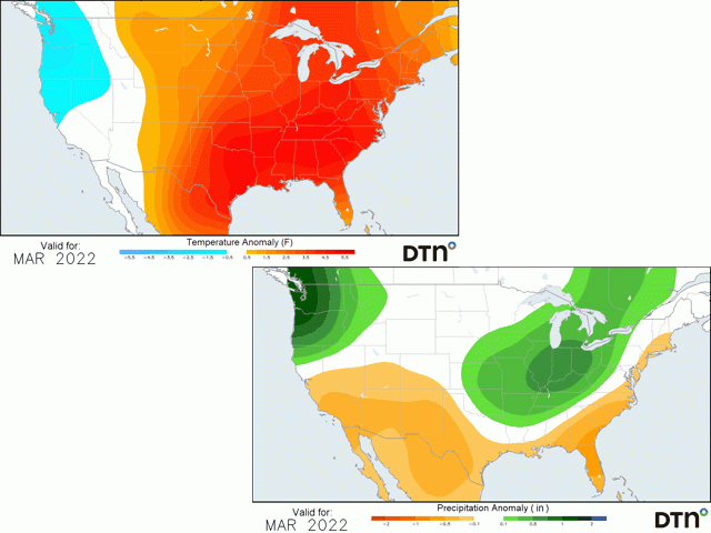
The Plains have followed this pattern, and drought has been steadily expanding from Kansas and Colorado southward. The lower Mississippi Valley or Delta region has also followed this pattern. But precipitation across the Southeast has not been as bad. Drier stretches have occasionally built drought conditions over the Carolinas, only to have a couple of deeper systems move through that are a break in the clipper pattern and overspread the region with better precipitation.
But this clipper-favored pattern cannot last forever, right? So, when does it end? It ends when the ridge over the Eastern Pacific moves.
P[L1] D[0x0] M[300x250] OOP[F] ADUNIT[] T[]
We do not see that in the models this week or next. But there are hints that the ridge could retrograde westward through the North Pacific the last week of February and through March.
The result would be a trough setting up over western North America and a likely ridge developing across the Southeast.
The favored storm track then would switch up significantly -- coming out of the West into the Southern Plains, then moving northeast into the Great Lakes. That could mean better precipitation chances across the Southern Plains, an area in desperate need of rainfall under extreme drought for winter wheat as it becomes more active again.
But that would only occur if that western trough can be strong enough. Otherwise, the storm track would favor a flatter track from the Central Rockies through the Midwest. That would leave the Southern Plains on the drier side of the storms.
I would assume we would see a mix of the two, given the long-range upper level air patterns we are seeing in both the American and European models. But it is the preference that is important. If we see more of a flatter pattern, expect drought to worsen for the southwestern Plains from western Kansas south through the Texas Panhandle. The southeastern Plains however, eastern Oklahoma and Texas through the Delta, may be on the beneficial side of the storm either way as this pattern would also favor opening up the moisture source in the Gulf of Mexico.
Either way, it favors below-normal temperatures west of the Rockies, and above normal temperatures east of the Rockies for the most part. The Northern Plains are likely to be more in the transition zone, however, seeing more of a mix of above and below-normal temperatures.
Models do not necessarily agree entirely on the pattern, however. The American model does not retrograde the ridge nearly as far as the European does, though it does show the western North America trough feature. And models can only give us some clues as to the weather that is coming up three to six weeks down the line, not the actual track of the storm systems. But it is something worthy of discussing as La Nina starts to break down and head toward a neutral state over the coming months. The clipper pattern will break, and it may be in just a couple of weeks.
On another note, I will be at the Louisville National Farm Machinery Show next week. There, I will discuss the long-range outlook through the 2022 growing season. If you are in town for the show, stop by the DTN booth and say hello! I would love to meet with you and learn about your farming operations.
To find more regional weather conditions and your local forecast from DTN, head over to https://www.dtnpf.com/…
John Baranick can be reached at john.baranick@dtn.com
(c) Copyright 2022 DTN, LLC. All rights reserved.

Comments
To comment, please Log In or Join our Community .