Ag Weather Forum
La Nina Remains in Effect
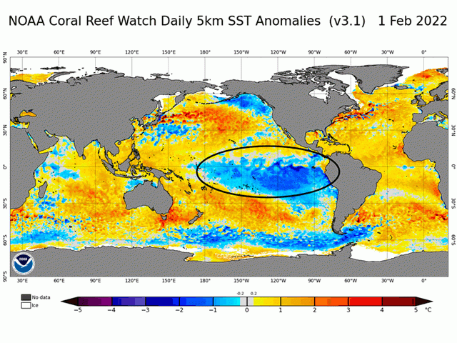
La Nina can be stubborn. This cool-water phase of the Pacific Ocean ENSO (El Nino Southern Oscillation) started during late summer back in 2020, weakened a bit during 2021, and then returned during the last few months of 2021 to be around again during 2022. The Pacific sea surface temperatures and barometric indicators used to track ENSO showed some weakening of La Nina values during January; however, those indicators are showing a more definite La Nina trend as we move into February. Pacific equatorial sea surface temperatures continue around 1 to 3 degrees Celsius (1.8 to 5.4 degrees Fahrenheit) below average from the International Date Line to the west coast of South America. The cool-water area is especially large south of the equator.
The Australia Bureau of Meteorology (BOM) closely tracks the back and forth of the Pacific details. The BOM describes the ocean situation in this way in its update Feb. 1: "Oceanic indicators of ENSO continue to show a clear La Nina signal, with cooler-than-average sea surface temperatures in the eastern tropical Pacific, and cooler sub-surface waters supporting the cooler waters at the surface. However, these cooler sub-surface waters continue to ease. Most atmospheric indicators also show clear La Nina patterns, with decreased cloudiness along the (International) Date Line and trade winds either close to average or slightly increased. While the 30-day Southern Oscillation Index (SOI) has experienced some short-term fluctuation, the 90-day SOI is still firmly in La Nina territory."
The two big crop weather impact features of La Nina during the period from November through February are dry conditions in the U.S. Southern Plains; and dry conditions in southern Brazil and northern Argentina. That dryness has indeed been in effect in these two regions during the past few months. In the U.S. Southern Plains, a lack of precipitation has helped drag winter wheat conditions down. Winter wheat condition ratings in late January totaled just 30% of the Kansas wheat crop judged as good to excellent, with a total of only 16% in Oklahoma and a meager 6% good in Texas. Poor to very poor ratings added up to 31% in Kansas, 43% in Oklahoma and a stark 76% in Texas. The Texas crop, incidentally, has a condition-based index value of only 25 compared with 55 in late January 2021.
P[L1] D[0x0] M[300x250] OOP[F] ADUNIT[] T[]
In South America, soybean crop production estimates as of the end of January are much lower than a month ago. The primary reason cited is significant dryness in southern Brazil and Argentina, squarely in the likely drought footprint of La Nina impact.
Meanwhile, U.S. drought is setting records. NOAA meteorologist Thomas Di Liberto highlighted this observation on the NOAA Climate.gov website:
"Overall, the 2020-22 drought continues to break records on a weekly basis, as the Jan. 25 drought monitor marked a record 70 weeks where at least 40% of the contiguous U.S. was drought."
Seventy weeks back takes us to the week of Oct. 1, 2020 -- about the time that the current La Nina began. Forecasts through the end of winter and early spring suggest the highest chance of above-normal precipitation in the eastern Midwest, the potential for above-normal precipitation in the Northern Plains and Northwest, but continued dry in the La Nina-affected dry Southern Plains. So yes, La Nina can be stubborn and reluctant to terminate its stay on the atmospheric center stage.
La Nina comments are also featured on the DTN Reporter's Notebook video available at this link: https://www.dtnpf.com/….
Bryce Anderson can be reached at Bryce.anderson@dtn.com
Follow him on Twitter @BAndersonDTN
(c) Copyright 2022 DTN, LLC. All rights reserved.


Comments
To comment, please Log In or Join our Community .