

Ag Weather Forum
Why It's Still Difficult to Forecast Next Week's Weather
When models show significant differences, it is hard to choose which direction to go and how to build a forecast. Earlier this week, I described the process that we have used here at DTN to settle these differences.
The European Centre for Medium-Range Weather Forecasting (ECMWF) and American Global Forecast System (GFS) have had slight differences in how they handle a ridge of high pressure across the Eastern Pacific Ocean up into Alaska since Jan. 24 and have not changed their stance on this too much. There has been a little compromise in both models, but overall, the differences in the ridge remain. The GFS is much more adamant about a stronger ridge, while the ECMWF breaks it down across Alaska. Models differ on temperatures and precipitation potential in the U.S. and Canada beyond Feb. 4.
You can see what I posted on Jan. 26 regarding the great differences the models said about temperatures, quite obvious from the graphics with my earlier blog at https://www.dtnpf.com/….
However, the differences between the two models have lessened a bit since then, and both have compromised some. The ECMWF has a little bit of a better location of some warmer air across the West that leaks into the Plains at times. The GFS has ceded that point to the ECMWF. But the GFS still brings down more cold air into the Midwest and Eastern U.S and Canada, and the ECMWF has ceded that point to the GFS.
As such, the pattern is starting to look more like the pattern we have seen during the last half of January, back into the clipper pattern with scattered showers through the Corn Belt and bouts of colder air.
DTN continues to trust the GFS suite more than the ECMWF suite based on the handling of conditions in the tropical Pacific Ocean, but the differences between the models still leaves us with a lower-confidence forecast.
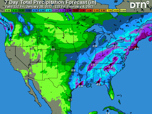
You can see the DTN precipitation forecast, as of Jan. 28, in today's graphic with this blog.
Below is my original blog from Jan. 26.
**
Weather forecasting is not a simple endeavor. When models agree, the job is easier, even if they are wrong. When they do not agree, it is hard to tell what to trust. How do forecasters decide what to do in this case? There are a lot of methods or paths that forecasters use, right or wrong, to distinguish between model differences.
P[L1] D[0x0] M[300x250] OOP[F] ADUNIT[] T[]
You can do the easiest method and just blend solutions together. But if they are diametrically opposed, one is going to win out over the other, and your forecast is going to look terrible and be subject to wild changes on a run-by-run basis. Doing so may make a forecaster look like he or she is not competent, even if the reasoning is sound.
You can choose a single model and stick with it, either based on previous performance or because of your bias (I am looking at you, ECMWF -- European Center for Medium-Range Weather Forecasts). But if that one model is wrong and changes to match a different model in subsequent runs, a forecaster can again look like a fool. I have done it multiple times before.
Or you can go the more diagnostic route and try to find out why those differences exist in the models. Then you can try and choose the more realistic reasons why a certain model may perform better than the others it disagrees with and use that as your forecast. You may still end up being wrong, however. Perhaps the reasoning you thought was more realistic turned out to be false. You again would look like a fool.
So, like many things in life where uncertainty is involved, a blended approach of all the data and methodologies is typically the better route to take, as long as you are able to explain the reasoning why.
That is where we sit today. A pattern change is coming to North America during the next week. But models do not agree on how that will take place, how long it will last, and what the effects will be going through the first half of February.
Overall, the differences in the depiction between the American Global Forecast System (GFS) model suite and the European ECMWF model suite are subtle. However, they produce drastic differences in the sensible weather across the continent beyond next Wednesday. They actually have pretty good agreement up until that point.
We have been under a constant pattern of a ridge in the eastern Pacific Ocean that has been nosing its way up into Alaska and northwest Canada for the past week. Meanwhile, a trough has been situated over Hudson Bay. This has allowed a train of clipper systems to move through North America on a pretty regular basis, with rounds of cold air and batches of light to moderate precipitation.
That ridge is about to make a brief move to the east. It will start to do so Jan. 27 and eventually spread across the U.S. and southern Canada through Feb. 1. In its place, a strong trough of low pressure will develop this weekend and deepen across the West by Feb. 1. We should see a good low-pressure system move from the Western states through southern Canada and the U.S., likely in a couple of pieces, Jan. 31 through Feb. 3. Widespread precipitation is likely to be the result and could bring some needed widespread moderate precipitation to the drought areas in the Plains. It would not bust the drought by any means but would pause the expansion. Severe weather would also be a risk closer to the Gulf Coast.
However, it is what happens next that models disagree on quite significantly. Looking at the GFS model suite, it has a much colder outlook across central North America than its European counterpart, which looks more progressive with the pattern than stagnant.
According to DTN Team Lead of Long-Range Weather Nathan Hamblin, it all has to do with a ridge over Alaska getting split ... or not. Models do not show any consistency in this, and it is leading to wide variability in temperatures and precipitation for early to mid-February.
According to Hamblin, "The ECMWF splits the ridge apart and develops this weird, elongated trough from Greenland (across the North Pole and) through the Central Pacific. This would cut the arctic air off completely and flood North America with mild, Pacific flow for early February, which would wreck the going forecast. The GFS keeps the ridge in place, even though it also retrogrades the pinched-off piece into Siberia. That ridge is the key to the forecast. The longer it remains, the longer the cold source can be tapped into."
With the ridge the key topic of consideration, it is curious as to what the differences might be between the two model suites. If we can find a cause, maybe we can choose our model guidance a little more carefully. Hamblin has a reason for this discrepancy, and it may be the weather that is forecast over what is termed the "Maritime Continent" region. For those unfamiliar, this is the area in the western tropical Pacific Ocean that is spattered with islands between mainland Asia and Australia, including the islands that make up Indonesia.
The European suite generally has a dry bias in this part of the world, said Hamblin. That could be the big key to why there may be differences between the models. And due to this quirk in the European model, he is leaning his forecast away from the European and toward the GFS suite. But he is quick to explain that he is not throwing out the European solution entirely.
"You have to hedge somewhat because, if you're wrong, you'll have to move to a very different place quickly, which will confuse your customers. You want the forecast to move steadily in one direction and not flip-flop if you can possibly help it."
That leads us back to our thought process for making a forecast. With Hamblin's insight, we have diagnosed a reason why the main two weather model suites are different and chose the GFS over the European. But we should still blend it in so that the forecast has elements of possible solutions, and that a flip-flop does not occur. Choosing this route opens up the forecast to be wrong, in either direction, and could make a forecaster look, well, like a fool.
"Everything I just said could be wrong. This pattern is hard, and I don't have a lot of confidence in the details," Hamblin concluded. Right you are, Nathan. Right you are.
To find more regional weather conditions and your local forecast from DTN, head over to https://www.dtnpf.com/…
John Baranick can be reached at john.baranick@dtn
(c) Copyright 2022 DTN, LLC. All rights reserved.

Comments
To comment, please Log In or Join our Community .