

Ag Weather Forum
Major Winter Storm Affecting US This Week

This should come as no secret as it has been well advertised, but a major winter storm is about to affect a large portion of the country through Feb. 4. The culprit is a brief hiccup in the upper-air pattern. We have seen a strong ridge of high pressure in the Eastern Pacific along with a deep trough in Hudson Bay that has been bringing us a series of clipper systems and a couple of Nor'easters during the last couple of weeks.
But we are seeing a chunk of the ridge split off and move through the United States during the last couple of days. It is strengthening in the east and the response is to bring warm, moist air from the Gulf of Mexico northward.
At the same time, a lobe of the Polar Vortex has built across the western half of North America in place of the ridge and is starting to send a couple of pieces eastward into that eastern ridge.
One piece of energy has already produced a clipper system that has moved across the U.S.-Canada border with moderate snowfall in Canada and strong winds in the Northern Plains and Upper Midwest that has produced blizzard conditions.
P[L1] D[0x0] M[300x250] OOP[F] ADUNIT[] T[]
The push-and-tug between the two upper-level features is going to stall the cold front from the clipper from the Southern Plains to the Northeast through Feb. 3 before the ridge erodes and allows the front to continue progressing eastward through the rest of the country.
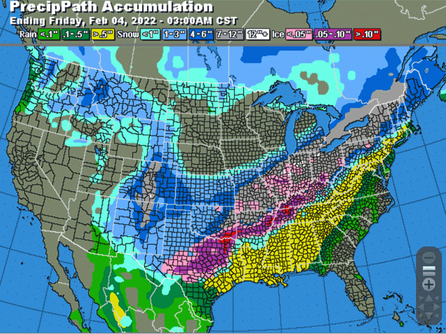
That brief stall will make all the difference in creating the winter storm. The dramatic change in temperatures on either side of the front will cause precipitation to develop, and it is starting to do so on the morning of Feb. 1 in Missouri. Rain will expand through Illinois up to Michigan and southwest into Oklahoma and Texas Tuesday night.
At the same time, cold, arctic air will filter in and build behind the front, changing the precipitation into a mix of freezing rain, sleet, and snow north and west of the front. With precipitation lasting through Feb. 3 before moving eastward, an equivalent of 1-to-2 inches of liquid water are set to fall from the southeastern Plains up through the eastern Midwest and eventually going from rain, to freezing rain, sleet, then snow. Widespread areas of 6-to-12 inches of snow and up to 0.50 inch of freezing rain are forecast and no doubt there will be areas that see more than those benchmarks.
The wintry precipitation will coincide with wind gusts in the 30-40 mph range that will cause potential for drifting snow and downed powerlines.
Snowfall in the southwestern Plains will not be as heavy. Most areas should see less than 6 inches. If you melt that down, it is on the order of 0.25 to 0.50 inch of liquid equivalent, not enough to reduce drought by any significant means. But it should cause some delay in the drought's expansion. And drought over the southeastern Plains into the southern Delta will likely see some improvement as liquid equivalent precipitation should exceed 1 inch for much of this area.
The cold that follows the system is also among the coldest of the season and some areas as far south as the Texas Panhandle and possibly up through the Ohio River Valley could see temperatures drop below zero Fahrenheit through Saturday morning. The extent of the cold will coincide with where the heaviest snow falls this week.
This storm system is one of the biggest so far this season with some of the most widespread impacts. We could see more of these types of systems as we head toward the end of February and into March. The upper-level features forecast in that timeframe favor a storm track from the Southern Plains through the Midwest. But the perfect matchup of heavy precipitation with a stalled boundary is not exactly easy to do. We could see more of these types of systems going into spring, but it is not guaranteed.
To find more regional weather conditions and your local forecast from DTN, head over to https://www.dtnpf.com/…
John Baranick can be reached at john.baranick@dtn.com
(c) Copyright 2022 DTN, LLC. All rights reserved.
Comments
To comment, please Log In or Join our Community .