
Ag Weather Forum
Up Now, Down Later for North America Temperatures
Arctic cold weather have been the focus across North America for the last two weeks. Several waves have spread across the United States. But outside of a long-standing cold blast in late December for Western Canada and the Northern Plains, these have moved through the U.S. and eastern Canada rather quickly with not a lot of staying power.
If you want to thank something in the atmosphere about why the cold has not been stuck in your area for a week or two at a time, a trough over Greenland that has developed has allowed an "avenue of escape" for the cold to sweep through North America. If you want to read more about some of those long-standing features, check out my blog from last week: https://www.dtnpf.com/….
But this week has turned warmer. The disruption that has weakened the polar vortex and allowed lobes of it to move across North America has gone briefly absent. Instead, the polar vortex has become a bit more stable and situated itself closer to the North Pole. This has allowed a ridge to develop across western North America during the last couple of days and spread across the continent.
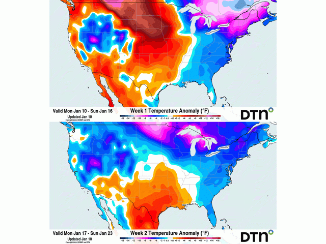
Conditions will be warmest in the Canadian Prairies through the Central and Southern Plains of the U.S. as downsloping winds help to bring temperatures 10 to 20 degrees Fahrenheit (5.5 to 11.1 degrees Celsius) above normal for several days during the next week.
P[L1] D[0x0] M[300x250] OOP[F] ADUNIT[] T[]
The high temperatures will not be a constant even in this warm stretch as little disturbances will move over the top of and underneath this ridge, eating away at it and pushing the core of it off the West Coast by the middle of next week.
These disturbances are mostly small and benign, but one will be a little stronger late this week and weekend. It is forecast to build in the Northern Plains late Thursday and into Friday then move into the Southeast during the weekend. Moderate showers will follow this system and could be a heavy snowmaker for the Western Corn Belt. Heavy rain would be possible in the Southeast. And the system will likely bring a brief break in the warmer pattern across much of Canada and the U.S., especially in the Northeast that could see some more arctic air moving through.
But that system will be just a hiccup during the next seven days of warmth and temperatures will rebound above normal for much of North America early next week.
But there is no stability in the pattern until we enter the middle of next week, and we see that ridge take hold across the eastern Pacific Ocean and extend up into Alaska. Doing this will upset the polar vortex again and get a lobe of it over northern Canada to pull down cold, arctic air back into the Canadian Prairies and down through much of the U.S.
With a low near Greenland, it should be a little more transient or come in bursts closer to the Rocky Mountains. But across the Great Lakes, Northeast, and eastern Canada, the cold will likely have more staying power. That is, for about seven to 10 days. Models suggest that the Eastern Pacific-Alaska ridge will shift farther west into Russia in early February and the trough will follow it westward, finding itself over western North America.
This should lead to colder conditions for western North America but ridging and above-normal temperatures to take shape across much of central and eastern North America. If a zone of sharp temperature contrasts shows up, which is what this pattern suggests, we should expect a more active storm track through the middle of the U.S. and Eastern Canada. Models are showing some good precipitation for early February across the Ohio Valley and Southeast up through the Northeast and far eastern Canada, which may be a bit too far southeast given the overall pattern. That, of course, is something to watch for in future weeks.
To find more regional weather conditions and your local forecast from DTN, head over to https://www.dtnpf.com/….
John Baranick can be reached at john.baranick@dtn.com
(c) Copyright 2022 DTN, LLC. All rights reserved.

Comments
To comment, please Log In or Join our Community .