

Ag Weather Forum
Long-Range Clues for North American Weather for the End of January
A fair warning -- I am talking big-picture upper air patterns and technical babble in this blog piece. It can be a confusing to hear new terms when you do not understand them, so I am risking losing you, the reader, with this. But there are some major ramifications that these terms can clue us in on what type of weather we can expect for the rest of January. So, I felt it was a good time to bring these up.
I, myself am not a complete expert on these features either. So, I am bringing in DTN Team Lead of Long-Range Weather Nathan Hamblin, who is an expert on these features, to help us sort it all out and understand the weather risks in the medium-to-long range. In this case, that is the second half of January.
We have seen two instances of cold, arctic air moving down from the North Pole due to the polar vortex in December and now in January. Models are forecasting a warmup for next week, but what will happen after that?
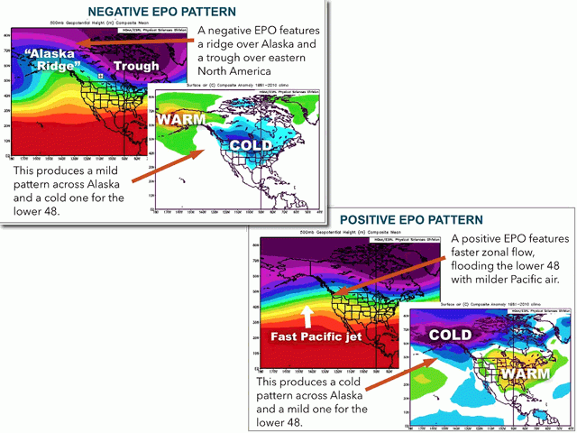
There are different ways to describe the upper-level troughs and ridges that drive our overall weather patterns that can bring us some insight to the big-picture of the atmosphere. We can combine something like higher-than-normal pressure in the upper-levels of the atmosphere (a ridge) over Alaska and lower-than-normal pressure (a trough) in Hawaii and call that a negative value, while calling the opposite a positive value. That is the basis for what is called the "Eastern Pacific Oscillation" (EPO) index. Sometimes it is easier to just talk about a positive or negative value of one of these terms instead of trying to describe or see the upper-air charts themselves to let you know what models are thinking about the overall weather pattern.
This is because we can associate positive and negative values of these indices with strong correlations for weather in other portions of the world. In this case, a positive value of the EPO correlates with above-normal temperatures east of the Rockies, so seeing positive EPO signatures in a forecast could clue us in that a warmup is coming. And, of course, the opposite is also true.
P[L1] D[0x0] M[300x250] OOP[F] ADUNIT[] T[]
Another of these indices is called the North Atlantic Oscillation (NAO). Its positive phase is associated with a trough over Greenland and a ridge across the central Atlantic. Its negative phase is again, the opposite.
Positive values of the NAO typically produce progressive patterns as winds easily flow from North America on toward Europe. Negative values indicate a blocking high pressure ridge over Greenland that can disrupt the polar vortex and cause systems to deepen across eastern North America and get stuck there, leading to lower temperatures for the eastern U.S. and Canada.
When you look at these indices by themselves, they can give you some clue as to what is going on in the atmosphere, but combining them and their signals usually leads to better understanding than looking at one versus another. That is especially true when forecasts of upper-air charts beyond day 10 like to wash out the important smaller-scale and sometimes larger-scale troughs and ridges and it becomes difficult to digest what is truly going on.
These indices are examples of teleconnections -- a fancy term that simply means weather patterns in one part of the world that influence the weather pattern for other areas of the world. The most common example of a teleconnection that you have heard of is the El Nino Southern Oscillation (ENSO) and the El Nino and La Nina conditions that are associated with its positive and negative phases, respectively.
It truly is like that old saying that "a butterfly flapping its wings in the Amazon causes ... " Weather is a global system and what happens in one portion of the world can affect the weather in others.
So, to our forecast, taking a look now at what models are saying about the EPO and NAO, we should talk with Hamblin. According to him, "the ECMWF Weeklies (long-range ensemble of the European model) show a decent period of negative EPO later in January. (The model) shows the ridge near or just west of Alaska. However, there is a persistent positive NAO signal shown on this model and all other guidance as well. Plus, the pattern will be in retrogression during the second half of the month."
OK, thanks Nate, but what does that mean?
It should mean, as Hamblin explains confidently, "a continued up and down (temperature) pattern with another one to two colder air masses coming down (from northwest Canada and the North Pole), but being swept eastward quickly due to progressive pattern with the positive NAO." Hamblin offered that it could be colder across North America, but that the positive NAO will allow for an "avenue of escape" for the cold air to sweep through the continent instead of getting locked in.
In other words, while North America is going to see a warmup next week, it is not going to last. With the EPO going positive and a ridge going back into Alaska, we should see pockets of colder air moving down through the continent every so often, but only lasting a couple of days and intermixed with more brief warmups as the pattern stays progressive due to the positive NAO.
Put even more simply: The roller coaster ride in temperatures will continue for the end of January.
If you are inclined to read more about the EPO, you can visit this page from DTN: https://www.dtn.com/…
John Baranick can be reached at john.baranick@dtn.com
(c) Copyright 2022 DTN, LLC. All rights reserved.

Comments
To comment, please Log In or Join our Community .