
Ag Weather Forum
La Nina Gets Stronger
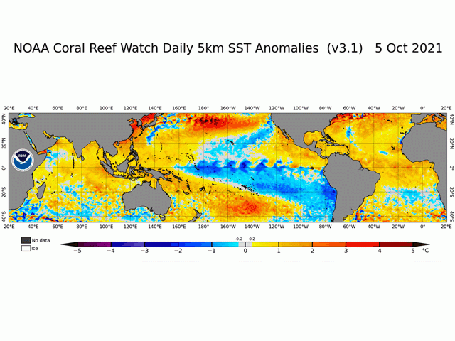
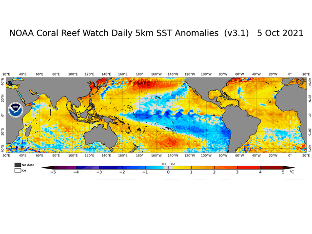
Early-October Pacific Ocean sea surface temperatures and barometric pressure studies indicate that La Nina is getting stronger as we move further into fall. Sea surface temperatures along the equator are as much as 3 degrees Celsius (about 5.4 degrees Fahrenheit) below average. The deeper waters are cool as well, with values running as much as 6 degrees C (about 10.8 degrees F) below average. The deeper-water cooling indicates that this pattern has support throughout the ocean profile.
Barometric pressure tendencies tracked by the Southern Oscillation Index (SOI) are also indicating the presence of La Nina. The SOI is tracked by the Australia Bureau of Meteorology (BOM); it compares the air pressure readings at Darwin, Australia and on the island of Tahiti. Sustained index values of greater than plus 7 point to La Nina. As of Oct. 7, the SOI had a daily value of plus 14.12; a 30-day average of plus 10.72; and a 90-day average of plus 9.73.
P[L1] D[0x0] M[300x250] OOP[F] ADUNIT[] T[]
Forecast models now call for La Nina to be around through the rest of 2021 and through the winter of 2022, with a slow weakening during spring of 2022. La Nina's influence in North America is most striking in its storm track configuration, as the jet stream shows a track from Alaska southeast to the Ohio Valley, then back northeast to the Canadian Maritimes. This pattern brings colder-than-normal conditions to the northern U.S. along with the Canadian Prairies, while the southern U.S. is warmer than normal including the Southern Plains and Delta. Precipitation shows a large contrast: above normal in the Pacific Northwest and the Ohio Valley, but dry in the Southern Plains and the Gulf Coast. Other areas have a variable precipitation trend.
La Nina strengthening implies a dry winter for the Southern Plains, which puts a premium on upcoming precipitation chances through mid-October. Meanwhile, higher chances for moisture in the northwestern U.S. offer some potential for drought easing. On the opposite end of the spectrum, the wetter outlook for the eastern Midwest indicates no drought concern but also some prospect of wet ground slowing down the start of spring fieldwork in 2022.
In South America, La Nina's greatest impact is likely to be in Argentina and Southern Brazil with dry conditions. Argentina growers may delay planting to try to avoid crops going into reproductive phases during the heart of the South America summer in December to January with La Nina still in place.
Bryce Anderson can be reached at bryce.anderson@dtn.com
Follow him on Twitter @BAndersonDTN
(c) Copyright 2021 DTN, LLC. All rights reserved.
Comments
To comment, please Log In or Join our Community .