Ag Weather Forum
Strong Storm to Have Significant Ag Impact Next Several Days
Rain, snow, severe weather, wind, freezing conditions -- this system is going to have a whole bevy of impacts for agriculture across the country through Saturday. And it has already started.
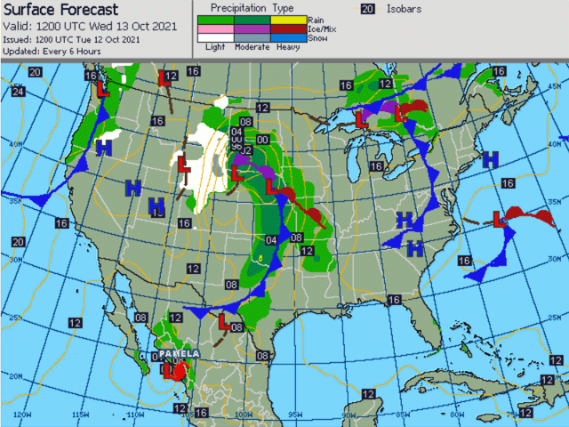
A deep trough of low pressure has been building in the western United States since Oct. 10. It brought some snow already to portions of the Intermountain West and has bled some of that snow into the front range across Wyoming and southern Montana as well. That is just the first sign of a big storm to come.
The trough is starting to develop a strong low-pressure center in Colorado that will move northeast through the Northern Plains through early Thursday. A cold front extending to its south will sweep across the Central and Southern Plains with scattered showers and thunderstorms. As the system moves north into Canada, it will diminish, however, but stall its cold front from the Ohio Valley southwest into Texas. That front will get picked up by another low-pressure center that will move along the front and sweep it out of the country on Saturday, leading to a period of almost a full week for major storm impacts across the country.
P[L1] D[0x0] M[300x250] OOP[F] ADUNIT[] T[]
Two systems have preceded this large storm, bringing some moderate to heavy rain and some severe weather across the Plains and into the Midwest. But this storm will have more far-reaching impacts. Moderate to heavy, steady precipitation will develop on Tuesday and follow the path of the low-pressure center through the Northern Plains and Minnesota.
To the west, it has already begun as snow, and that looks to continue from about the Black Hills westward. It should be just warm enough for rain elsewhere. But the rains will come with widespread amounts of 1 to 3 inches that should delay harvest. Snow is pegged anywhere between 8 to 24 inches when all is said and done, bogging down pastures and affecting livestock producers.
To the south, a line of scattered thunderstorms is expected Tuesday afternoon that should coalesce into a line of storms Tuesday night with all modes of severe weather possible transitioning to more of a strong wind threat as storms gel together. The severe threat will be more muted but continue into the Midwest on Wednesday and could repopulate across the Southern Plains and Delta regions on Thursday and Friday as the system sweeps the stalled front eastward. Damage will be possible to fields yet to be harvested, but the rains will be good for drier areas of the Southern Plains for winter wheat establishment. Some areas of the southwestern Plains, from western Kansas down into West Texas are going to be missed, however.
Another hazard comes with strong winds. Ahead of the storm, winds could eclipse 40 miles per hour in some areas ahead of the cold front in the southern High Plains on Tuesday, and across Iowa and Minnesota on Wednesday. Winds on the backside of the system are likely to be stronger across Nebraska and the surrounding areas where wind gusts of 50 to 60 mph will be possible on Wednesday. More damage to unharvested crops will be possible in these areas.
And then comes the cold. However, it will be more in line with what we would expect for the fall season than anything bone-chilling. Most areas east of the Rockies have yet to see their first frost outside of some low-lying areas in the Northern Plains and Upper Midwest. We are now in the realm of first frosts either coming on time, or late, as was forecast for the last several months. Temperatures in the Plains behind the storm will not get overly low. Outside of areas with heavy snow, temperatures are more in line to be in the upper 20s to middle 30s Fahrenheit across the Central and Northern Plains through the weekend before temperatures moderate a bit more. Other areas in the Midwest and Southern Plains are still expected to stay warm enough to hold off the first frost for a while yet.
There are a lot of impacts to put together with this storm system. The rain, snow, severe weather, wind, and cold will all have significant impacts to agriculture across the country through Oct. 16.
Generally, there will be widespread delays to the ongoing corn and soybean harvest along with potential for damage. Some flood risks are possible, especially in the southeastern Plains where the front stalls. Livestock areas from the Black Hills westward will see harsh conditions from accumulating snow, heavy in some areas. The first frost should set in for many areas from far western Kansas and Nebraska northward.
But on the bright side, some beneficial rainfall will occur for some of the winter wheat areas. This storm system is only getting started, and it is set up to be a whopper.
John Baranick can be reached at john.baranick@dtn.com
(c) Copyright 2021 DTN, LLC. All rights reserved.


Comments
To comment, please Log In or Join our Community .