

Ag Weather Forum
El Nino is Almost Here -- How Strong Will It Get?
Sea-surface temperatures in the tropical Pacific Ocean have been rising faster than normal during the last couple of months. The Pacific officially made it out of La Nina and into neutral conditions in March.
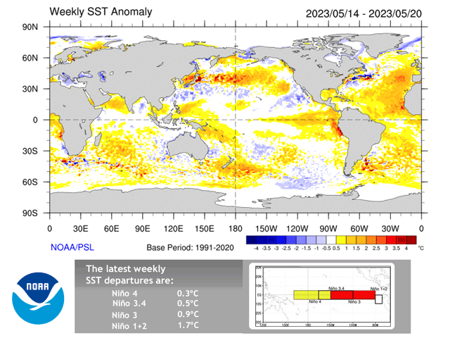
But since then, temperatures have continued to rise faster than normal. During the past two weeks, the main region of focus, the Nino 3.4 region, has technically met the criteria for El Nino (positive 0.5 Celsius anomaly or greater). You can find more about the different Nino regions here: https://www.ncei.noaa.gov/…. However, the Climate Prediction Center (CPC) requires this region to average the threshold for at least three months, so it will take a bit of time to make El Nino in 2023 official. That does not mean that the atmosphere will wait to respond, though.
Weather conditions in the U.S. have been quite anomalous for some time now, going back through winter with heavy precipitation across the West and Mississippi Valley. Over the last couple of weeks, that has shifted to a much wetter Great Plains and drought has been reduced to the lowest levels since June 2020. You can read more about that here: https://www.dtnpf.com/….
The switch out of La Nina has had something to do with it, though other sub-seasonal weather factors have contributed as well.
As the Pacific trends toward El Nino, the atmosphere will continue to adjust, but getting to an El Nino base-state should come into play during the fall. However, that depends on how strong El Nino eventually becomes and how quickly it does so.
P[L1] D[0x0] M[300x250] OOP[F] ADUNIT[] T[]
Waters off the coast of South America have been very warm since February and have contributed to the erosion of the cold, La Nina waters throughout the spring.
What has been holding back temperatures in the central Pacific Ocean has been a pool of cooler waters off the coasts of California and Mexico, in large part from the active pattern that developed this winter in that part of the Pacific. That pool has been seeping into the Nino 3.4 region during the last couple of months and has kept temperatures from rising too rapidly.
But when those cooler waters fade, El Nino may make a sudden and strong appearance. A warm pool of water over the north-central Pacific is doing its part to erode those cooler anomalies in the eastern Pacific. It may take another couple of weeks, but El Nino may be coming on strong.
Global climate models have been projecting an El Nino this year but to varying degrees. The American Climate Forecast System model (the primary climate model run by NOAA) has been so bold as to predict a "super El Nino" by this coming fall for the last few months. A super El Nino generally refers to an abnormally strong, when the temperature anomalies in the Nino 3.4 region reach above a positive 2.0 Celsius reading. The Australian Bureau of Meteorology (BoM) model also predicts a Super El Nino this year. Other forecasts are not as bold, but still suggest a moderate-to-strong El Nino (positive 1.0-2.0 C anomaly). It just so happens that both the CPC and BoM are the two centers that are the authority when it comes to the El Nino Southern Oscillation (ENSO) classification, and both have very strong forecasts for the event this year.
Only a handful of super El Ninos have occurred in recent history, one in 1982-83, another in 1997-98, and a third in 2015-16. The most recent one produced a peak anomaly of positive 2.6 Celsius, the strongest El Nino on a relatively short record of the last 73 years. To have two only eight years apart is something extraordinary but gives us a recent look at what conditions over the rest of the year may become.
Summertime 2015 was wet across a lot of the country outside of the Gulf Coast and Pacific Northwest. Those drier areas were also quite warm, but so were other areas in the West, Plains, and Southeast. The Corn Belt was largely cooler than normal. The fall was hot with record temperatures in the Upper Midwest and above-normal temperatures for the entire country. Precipitation was a lot more variable with some areas above normal and others below.
But even with 2015 being a close marker, no two El Ninos are the same. The trajectory that the Pacific Ocean temperatures took was different in 2015 than earlier this year and the year before, 2014, was not a La Nina year like we have just gone through, so it is hard to equate the two.
But there are tendencies for El Nino on how that will affect the weather patterns across North America. You can read more about them here: https://www.dtnpf.com/….
And North America is not the only area that is affected by El Nino. Australia and South America are heavily influenced as well. DTN's Bryce Anderson discussed the potential impact on Australia here: https://www.dtnpf.com/….
El Nino, whether strong or not, can have devastating climate impacts across the globe. Though the impacts can be a net-positive in the Central U.S., other areas of the globe can see catastrophes including extreme heat, flooding, and ocean bleaching. Read more about the costs of El Nino by Anderson here: https://www.dtnpf.com/…
To find more weather conditions and your local forecast from DTN, head over to https://www.dtnpf.com/…
John Baranick can be reached at john.baranick@dtn.com
(c) Copyright 2023 DTN, LLC. All rights reserved.

Comments
To comment, please Log In or Join our Community .