
Ag Weather Forum
Potential for Heavy Rain Next Week for Some of Canadian Prairies

It was rather dry this week and some folks were able to make some good seeding progress in the Canadian Prairies. Both Manitoba and Saskatchewan reported significant increases on their reports this week. On Friday, Alberta reported seeding had jumped 31% within a week, and now had 55% of all its crops seeded -- only 3% off the 5-year average. While some spots are a bit slower, due to last week's rainfall, still overall significant progress was likely made.
The dryness remains a concern, however, with wildfires and drought plaguing the region. More rainfall is needed, even if it does delay some seeding progress. Mother Nature may have a partial remedy next week. An upper-level ridge has been keeping the region mostly warm and dry this week, though there was a cold front that brought a few light showers to eastern areas and a brief dip in temperatures. That is gone though, and the warmth and dryness continue into the weekend. A possible shower here or there are not out of the question.
But by Sunday, the pattern changes. The ridge will start shifting off to the east and a weak trough will develop over British Columbia. That should force a low-pressure center to develop in Alberta on Sunday and generate some isolated or scattered showers for Alberta into Saskatchewan. The low center will sit there for a few days next week, which will enhance precipitation probabilities for the northern half of the region. Scattered showers will develop after that, though models are all over the board in terms of coverage and intensity.
P[L1] D[0x0] M[300x250] OOP[F] ADUNIT[] T[]
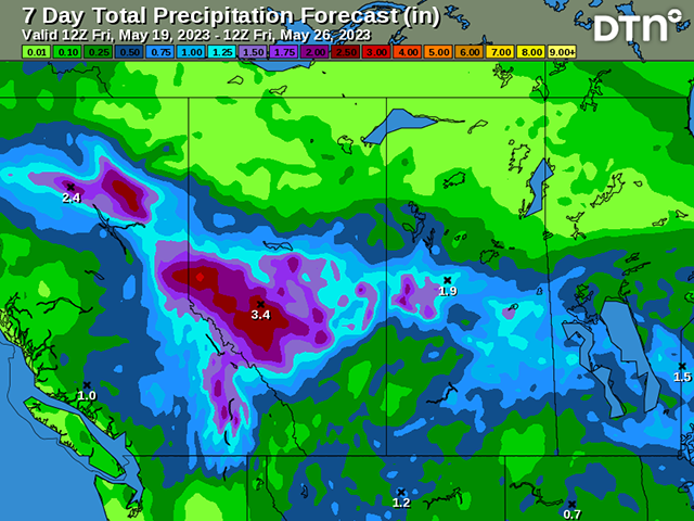
Still, this should be seen as a relatively good chance at widespread precipitation through the region for the last full week of May. The rain is forecast to be heaviest over the northern half of the region, with amounts over 30 millimeters (about 1.20 inches) being forecast for the northern half of Alberta and far northern agricultural areas of Saskatchewan. Areas over 50 mm (about 2 inches) are possible for northern Alberta, especially the Peace region. That is the area dealing with widespread wildfires and will welcome the rains to help fight them. Smoke from the wildfires has been inundating the region during the week and have even reached into the U.S. Corn Belt; the smoke triggered air quality health advisories in several provinces and states.
The more sporadic nature to the showers across the south will likely help producers seed more of their acres while catching some rains in the process as well. There could be some delays for those that get hit too many times. And undoubtedly, there will be areas that get missed.
This is likely a precursor to a weather pattern that should produce regular rain chances throughout the summer, though there is a risk of reduced rainfall amounts. As the atmosphere moves to an El Nino base-state in the coming weeks, warmer weather will be favored later in summer and any reduction in precipitation or lingering drought areas could see some stresses mounting.
To find more international weather conditions and your local forecast from DTN, head over to https://www.dtnpf.com/…
John Baranick can be reached at john.baranick@dtn.com
(c) Copyright 2023 DTN, LLC. All rights reserved.
Comments
To comment, please Log In or Join our Community .