
Ag Weather Forum
2022 Severe Weather Season Status Update After June 7 Hailstorm
The active pattern of the spring has led to many severe weather events in the last couple of months. Most recent is the large hail event that occurred in portions of the High Plains and Nebraska on June 7. More than 36 reports of hail with diameters greater than 2 inches make this event the most significant hailstorm of the season to date.
Assessing that damage and making decisions on replanting, spraying fungicides, or taking insurance payments can be challenging. DTN Crops Technology Editor Pam Smith wrote about some of the resources producers can use to guide them through the process here: https://www.dtnpf.com/….
Getting now into the first part of June, the "severe weather season" is roughly half over. The period between early April and mid-August account for roughly 75% of severe weather reports in a calendar year. Severe weather is defined as either a tornado, a thunderstorm wind gust of at least 58 miles per hour, or hail larger than 1 inch in diameter (the size of a quarter).
P[L1] D[0x0] M[300x250] OOP[F] ADUNIT[] T[]
Though there have been several waves of severe weather that have gone through the country so far this year, overall, the extent of severe weather has been less impressive than average. But that does not hit all three severe weather components equally.
As of June 7, according to data from the Storm Prediction Center, total tornado reports for the year have reached a total of 837. The average during the last 15 years through this date is 809. That is very close to average. Tornadoes got an early start across the Southeast with events in late March and early April. Four different events with more than 70 tornadoes each occurred in this time frame mostly from Texas through South Carolina, but also across the Ohio Valley and Iowa on April 12-13. The occurrence of tornadoes in severe storms has been on a slower pace since mid-April.
Through the same time period, damaging wind reports have been above normal. So far, there have been 5,756 damaging wind reports when the average during the last 15 years has been 4,674. That accounts for not just winds recorded over 58 mph, but also damage that occurred because of strong storms. The largest and most significant event occurred on May 12 when a derecho formed in northeast Nebraska and moved north-northeast through portions of northwest Iowa, eastern South Dakota, and western Minnesota. The event recorded 439 wind reports, 67 of those being greater than hurricane force (74 mph), along with 34 tornadoes. Dust covered the skies with a haboob, eroding topsoil and possibly carrying fertilizer out of their intended areas. Other large wind events occurred with the tornado outbreaks mentioned above.
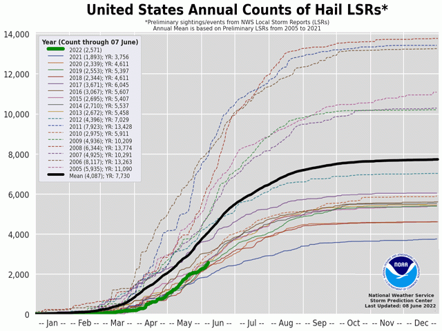
In contrast to the number of damaging wind reports, through June 7, hail reports have been below normal: 2,571 hail reports have been reported while the 15-year average through this date is 4,087. Hail reports during the year have so far been relatively spread out and isolated. But there have been a couple of events of large hail. In addition to the event on June 7, there have been four more days that have had more than 20 reports of hail with diameters greater than 2 inches. One occurred in the Plains on April 22, another in West Texas on May 1, another across the Midwest and Mid-Atlantic on May 19, and one more on Memorial Day in southeast Kansas through northwest Texas.
When added all together, the total of 9164 severe reports as of June 7 is behind the 15-year average for the date of 9570. But that is still a lot of reports of potential damage and devastation to the country's farming community. Whether it has been a large event like the derecho on May 12 and tornado outbreaks in the south, or smaller events like a pop up hail storm, severe weather is always a threat to agriculture. Luckily so far this year, the number of events has been below normal and many have come before much of the crop has been put into the ground. Damage to outbuildings and equipment have been reported, but damage to crops has so far been relatively isolated.
To find more regional weather conditions and your local forecast from DTN, head over to https://www.dtnpf.com/…
John Baranick can be reached at john.baranick@dtn.com
(c) Copyright 2022 DTN, LLC. All rights reserved.

Comments
To comment, please Log In or Join our Community .