

Ag Weather Forum
Another Blizzard to Hit Northern Plains and Canadian Prairies This Weekend

One-to-2 feet of snow, with reports up to 30 inches, were noted from a blizzard that affected the Northern Plains and eastern Canadian Prairies from April 12-15.
The hardest hit areas were from North Dakota into southern Manitoba where snowfall reports were consistently in that heavy range across most of the whole area outside of the southeast corner of North Dakota, where conditions were a little too warm for the precipitation to turn to heavy snow. A system moving through this weekend will have somewhat similar impacts. More on that below.
The moisture with the previous storm was welcome, as it fell across areas that continue to be in long-standing drought going back through 2020 in some instances. Heavy precipitation has been tough to come by. When this melts, it will leave soils very wet, a different feel from last season.
Though as many folks know around those parts, you cannot get some beneficial weather without a turn in the other direction as well. Indeed, that storm system also brought strong winds. For three days, gusts were regularly in the 40 to 55 miles per hour (64 to 88 kilometers per hour) range with peak gusts eclipsing 65 mph (105 km/h) at times in a few areas. That sent snow drifts into the extreme and pictures all over social media were posted with overpasses being buried as well as calves and cattle. Laying down to take a rest out in the open would quickly cause any animals to become buried in the heavy, wet snow. No doubt cattle losses have been significant, especially the young calves.
According to Shaylynn and Tristan Stark, livestock producers in Baker, Montana, the conditions were devastating. "We lost about a quarter of the calves we had on the ground, but we won't know the full extent of our losses until the drifts melt, we're afraid. The snow came so fast and when accompanied by vicious winds, calves got covered up."
P[L1] D[0x0] M[300x250] OOP[F] ADUNIT[] T[]
This snowstorm had a double-edged sword take on it, and there is another one coming up as well. You can read more about the impacts that this last system had here: https://www.dtnpf.com/….
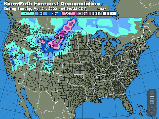
Warmer weather coming into the Plains ahead of the next system, providing another surge of energy to fuel a strong event. It will not be a three-day event like the last blizzard, but significant moisture and cold air will combine to produce more heavy snow and strong winds that will create another blizzard for April 23 into April 24.
The warm air that comes ahead of the storm will not exactly make it too far north into the current snowpack, which is mostly confined to North Dakota, southeast Saskatchewan, and Manitoba as the rest has melted away. But it will still get warmer ahead of the storm to melt some of it. Rains will move into North Dakota April 22 that will also do their part in melting some of the snowpack. That water has limited avenues to go as ditches filled with snow have frozen and will limit the escape. Overland flooding is likely a result. Then the cold air will settle in Friday night and turn the rains over to snow for Saturday and it will be heavy.
Temperatures bordering on the freezing mark will create wetter, heavier snow -- the kind that sticks to just about anything and piles up. It may even create some areas of freezing rain in western North Dakota and southwest Manitoba. But the heavy snow, which has been consistently forecast by models to fall across the western Dakotas, eastern Montana, and eastern Wyoming through southeast Saskatchewan and most of Manitoba looks to make a run at the totals we saw with the last storm. Forecast amounts are a bit less, with heaviest snow ranging from 8 to 18 inches (20 to 46 centimeters), but there are some indications that it could be more in some spots right along the Montana-North Dakota border into southeast Saskatchewan and western Manitoba.
Snow will gradually diminish from west to east late Saturday into April 23-24, but it will not be the only trouble.
Winds will continue to blast the Northern Plains and Canadian Prairies through the day Sunday. Strong winds will be common throughout the precipitation event anyway. Gusts of 50 to 60 mph (80 to 96 km/h) will be common yet again on Saturday. On Sunday, we may see a bit of a decrease overall to 40-55 mph (64 to 88 km/h). But there should be some peak gusts above that. We should expect to see more blowing and drifting snow and another round of livestock losses.
The last storm system did bring relief to drought in western North Dakota and likely in the eastern Canadian Prairies as well, though that information will not be updated until early May. On the U.S. drought monitor released on April 21, a full category of drought relief was noted for that half of North Dakota, but did not extend into Montana or Wyoming, where precipitation was also fairly heavy, a testament to the depth of the drought in the area. This coming system has potential for another 1.5 to 2.5 inches (38 to 63 millimeters) of liquid equivalent of rain plus snow for most of North Dakota and Manitoba, and in the heavy snow in western South Dakota, eastern Montana, and portions of Wyoming and southeast Saskatchewan. Further drought reduction looks to be a likelihood.
Snow again should be slower to melt than you would expect in late April. Low temperatures that move in to create the snow will also stick around for several days next week, only moderating slightly. High temperatures are unlikely to make it out of the 40s Fahrenheit (4 to 10 Celsius) for too many areas. The slower process may help to keep flooding down, but the amount of liquid equivalent being poured onto soils do not have the capacity to soak it all in. Flooding will probably be a concern for these areas outside of North Dakota, where the flood risk is already being mentioned.
Another big storm for the region will have more significant impacts to the region which may extend beyond livestock producers and into the grains. Wet soils this late in the season make it difficult to get planting done in a timely fashion. If the cold and wetness stick around for too long, we could see prevent planted acres get a bump. Monitoring the soil moisture and temperature during the next few weeks is going to be key to that becoming a reality.
The good news is that after this weekend, there should be a good stretch of dry weather next week. Another storm system may be possible next weekend, but is not likely to be strong, and models are still trying to decide whether or not it will organize or not.
To find more regional weather conditions and your local forecast from DTN, head over to https://www.dtnpf.com/…
John Baranick can be reached at john.baranick@dtn.com
(c) Copyright 2022 DTN, LLC. All rights reserved.
Comments
To comment, please Log In or Join our Community .